
|
|
| FRANCE | FRANCE |
| région: Auvergne-Rhône-Alpes | |
| département: 74, Haute-Savoie |
map →
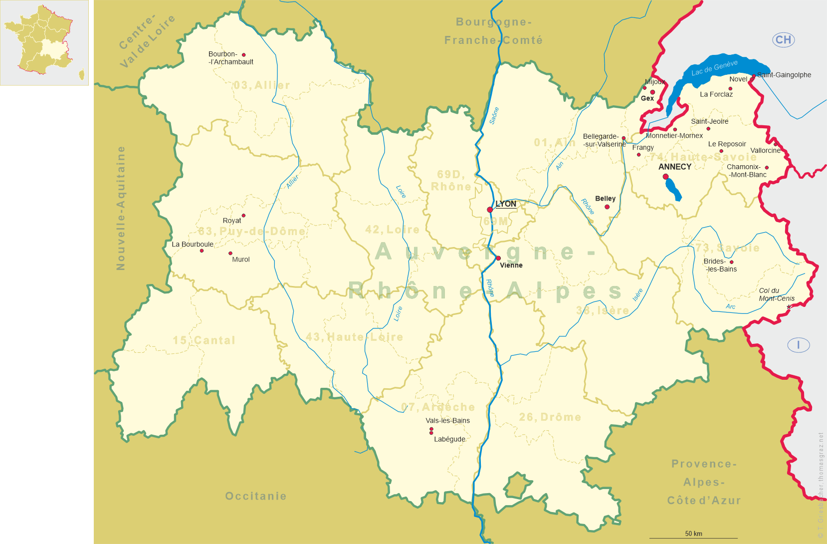
Saint-Jeoire is situated at an elevation of 569 m in the Vallée du Risse, northeast of the confluence of the rivers Risse and Giffre, about 37 km northeast of Annecy, the chef-lieu of the département Haute-Savoie, and about 132 km northeast of Lyon, the capital of the région Auvergne-Rhône-Alpes, and only 25 km southeast of Geneva in Switzerland. As of 2020, the municipality has a population of about 3,400. Since 2010 it is part of the Communauté de communes des Quatre Rivières. To avoid confusion with Saint-Jeoire-Prieuré, the name Saint-Jeoire-en-Faucigny is often used, but this has not been official since 1860. Jeoire is derived from the Latin name Georgius, refering to Saint George of Lydda.
 Around the year 1000, Benedictines settled on the site of the village, where they raised a small chapel under the name of Saint-Georges,
who gave its name to the village. The oldest documents mentioning the existence of the village date from 1185, and there is already mention
of a lord of Saint-Jeoire. In 1269, the village was a mitralie, a tax collection centre. In the Middle Ages, Saint-Jeoire was part of the
domains of Faucigny. As part of the Dauphiné, the place came to France in 1349, but was given to the Counts of Savoy in a land swap
following the Treaty of Paris of 1355. In 1565, Saint-Jeoire received certain privileges, including the status of a market town. During the
war between Geneva and Savoy, the town and the surrounding castles were severely affected. In 1772, King Carlo-Emanuele III of
Sardinia-Piemonte, Duke of Savoy granted the communes the possibility of repurchasing seigniorial rights, which was done in Saint-Jeoire in
1785: the inhabitants therefore no longer paid taxes to the lords. During the period of the French Revolution, in 1795, the municipality was
part of the département du Mont-Blanc and was renamed Ambion. During the Empire, it became Saint-Jeoire again, now
placed in the new département du Léman. Following the Congress of Vienna (1814) and the (Second)
Treaty of Paris (1815) most of Savoie was returned to the Kingdom of Sardinia. Following the Treaty of
Turin (1860), Savoy was ceded to France.
Around the year 1000, Benedictines settled on the site of the village, where they raised a small chapel under the name of Saint-Georges,
who gave its name to the village. The oldest documents mentioning the existence of the village date from 1185, and there is already mention
of a lord of Saint-Jeoire. In 1269, the village was a mitralie, a tax collection centre. In the Middle Ages, Saint-Jeoire was part of the
domains of Faucigny. As part of the Dauphiné, the place came to France in 1349, but was given to the Counts of Savoy in a land swap
following the Treaty of Paris of 1355. In 1565, Saint-Jeoire received certain privileges, including the status of a market town. During the
war between Geneva and Savoy, the town and the surrounding castles were severely affected. In 1772, King Carlo-Emanuele III of
Sardinia-Piemonte, Duke of Savoy granted the communes the possibility of repurchasing seigniorial rights, which was done in Saint-Jeoire in
1785: the inhabitants therefore no longer paid taxes to the lords. During the period of the French Revolution, in 1795, the municipality was
part of the département du Mont-Blanc and was renamed Ambion. During the Empire, it became Saint-Jeoire again, now
placed in the new département du Léman. Following the Congress of Vienna (1814) and the (Second)
Treaty of Paris (1815) most of Savoie was returned to the Kingdom of Sardinia. Following the Treaty of
Turin (1860), Savoy was ceded to France.
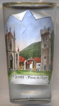
The  church of Saint George [left, no. 4481] originally dates back to the 11th century.
The massive bell-tower was rebuilt in 1740–1759, but parts of the medieval structure of the tower remained. During the occupation of
Savoy by French troops, from 1792 to 1815), the building was desecrated and degraded, and the church finally was left in a deplorable state.
In 1855 it was decided to demolish and rebuild the old church. The new church was built in neo-Gothic style in 1856–1858 separate from
the old bell tower, which was preserved. It was rebuilt in 1856–1858 in neo-Gothic style. Only the Romanesque tower remains of the old
church. In 1878, the bell tower, which was in danger of ruin, had to be restored; the top of the tower was then replaced by a cemented platform
decorated with battlements. The church underwent restoration again in 1989.
church of Saint George [left, no. 4481] originally dates back to the 11th century.
The massive bell-tower was rebuilt in 1740–1759, but parts of the medieval structure of the tower remained. During the occupation of
Savoy by French troops, from 1792 to 1815), the building was desecrated and degraded, and the church finally was left in a deplorable state.
In 1855 it was decided to demolish and rebuild the old church. The new church was built in neo-Gothic style in 1856–1858 separate from
the old bell tower, which was preserved. It was rebuilt in 1856–1858 in neo-Gothic style. Only the Romanesque tower remains of the old
church. In 1878, the bell tower, which was in danger of ruin, had to be restored; the top of the tower was then replaced by a cemented platform
decorated with battlements. The church underwent restoration again in 1989.
[https://de.wikipedia.org/wiki/Saint-Jeoire, https://fr.wikipedia.org/wiki/Saint-Jeoire;
http://fallingrain.com/world/FR/B9/SaintJeoire.html;
https://fr.wikipedia.org/wiki/%C3%89glise_Saint-Georges_de_Saint-Jeoire]
![[scale]](lineal.jpg)