
|
|
| ÖSTERREICH | AUSTRIA |
| Bundesland: Niederösterreich | Lower Austria |
| Bezirk: Zwettl |
map →

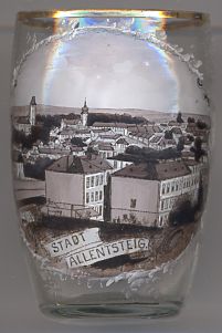
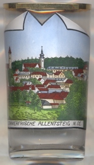
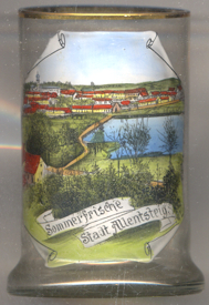
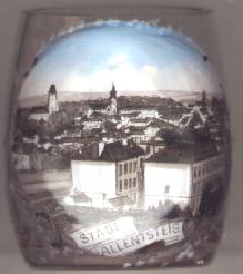 Allentsteig is situated at an elevation of 550 m in the Waldviertel region of Lower Austria in the area of the springs of the river Kleine Thaya.
Around 1080 the Kuenringer family built a castle at this place which became known as Tygia or Tigia, a name of Illyrian origin which is related to the later name of the river, Thaya.
A (possibly falsified) document of 1132 refers to the establishment of an independent parish. From Adeloldstige in the 12th/13th century, the name developed into the modern Allentsteig by about 1700.
The first mentioning as a town dates from 1380, the right to hold markets was granted in 1403.
Allentsteig is situated at an elevation of 550 m in the Waldviertel region of Lower Austria in the area of the springs of the river Kleine Thaya.
Around 1080 the Kuenringer family built a castle at this place which became known as Tygia or Tigia, a name of Illyrian origin which is related to the later name of the river, Thaya.
A (possibly falsified) document of 1132 refers to the establishment of an independent parish. From Adeloldstige in the 12th/13th century, the name developed into the modern Allentsteig by about 1700.
The first mentioning as a town dates from 1380, the right to hold markets was granted in 1403.
The whole area between Allentsteig, Kamp, Stift Zwettl and Neupölla, consisting of the market town Döllersheim and 50 further villages with a total of about 7,000 inhabitants, was evacuated and used for a military training (originally named for Döllersheim) area from 1938 on by the German Wehrmacht. From 1945 until 1955 it was used by the Soviet Army. Since 1957 it is in use by the Austrian army, the training area was reduced in size to 157 km² and renamed for Allentsteig.
 The
The  church of Sankt Ulrich [near left, no. 4114: background centre] is the Catholic parish church
of Allentsteig. The parish was first mentioned in 1132 when the parish was separated from that of Altpölla. The church is dedicated to Saint
Ulrich of Augsburg. The original, Romanesque church
was enlarged several times. In the 14th/15th century it was remodeled in Gothic style. Baroque additions followed in the late 17th century.
The interior was remodeled in Gothic revival style in 1893. The south aisle was added in 1904. Five new bells were installed in 1949.
church of Sankt Ulrich [near left, no. 4114: background centre] is the Catholic parish church
of Allentsteig. The parish was first mentioned in 1132 when the parish was separated from that of Altpölla. The church is dedicated to Saint
Ulrich of Augsburg. The original, Romanesque church
was enlarged several times. In the 14th/15th century it was remodeled in Gothic style. Baroque additions followed in the late 17th century.
The interior was remodeled in Gothic revival style in 1893. The south aisle was added in 1904. Five new bells were installed in 1949.
[https://www.allentsteig.info/kirche]
![[scale]](lineal.jpg)