
|
|
| ČESKÁ REPUBLIKA | CZECH REPUBLIC |
| Jihočeský kraj | South Bohemia (České Budějovice) region |
| Okres: Strakonice |
map →
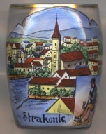
 Strakonice is situated at an elevation of 382 m at the confluence of the rivers Otava (Wottawa) and Volyňka (Wolinka) in South Bohemia.
Strakonice was first mentioned in 1243, when the Knights of the Order of St. John of Jerusalem (Knights of Malta) obtained the castle of Strakonice which became
the order's residence. From 1260 until 1730, Strakonice was the residence of the order's Grand Prior. After 1730, it was a deanery of the Knights of Malta.
Strakonice obtained the status of a town prior to 1308.
The Jewish cemetry of Strakonice, with tombs dating from 1736 until the 20th century, is recognized as a cultural monument.
Strakonice is situated at an elevation of 382 m at the confluence of the rivers Otava (Wottawa) and Volyňka (Wolinka) in South Bohemia.
Strakonice was first mentioned in 1243, when the Knights of the Order of St. John of Jerusalem (Knights of Malta) obtained the castle of Strakonice which became
the order's residence. From 1260 until 1730, Strakonice was the residence of the order's Grand Prior. After 1730, it was a deanery of the Knights of Malta.
Strakonice obtained the status of a town prior to 1308.
The Jewish cemetry of Strakonice, with tombs dating from 1736 until the 20th century, is recognized as a cultural monument.
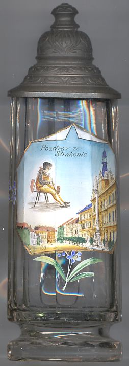
The picture on glasses no. 2447 [left] shows views of the
square  Velké Marian
The building in the background right of the picture of glass no. 2447
[left] is the former Town
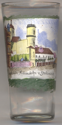
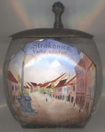 Glass no. 3371 [right] shows a view of Palackého náměstí
(Palacký Square), with the Marian Column (see above) depicted in the foreground left, which means that this glass dates from a time after the
monument had been moved from its original location to this place.
Glass no. 3371 [right] shows a view of Palackého náměstí
(Palacký Square), with the Marian Column (see above) depicted in the foreground left, which means that this glass dates from a time after the
monument had been moved from its original location to this place.
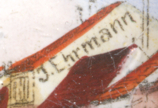
The top part of the yellow building centre right is labeled J. Ehrmann. Joseph Ehrmann (1855–1935) was a merchant for haberdashery and glass. His youngest son, Robert Ehrmann, is the author of the book Strakoničtí souvěrci: Ze života Židů na malém městě ('Strakonice fellow believers: From the life of the Jews in a small town'), Prague, posth. 1998. Only Robert and Joseph's brother Leopold succeeded to escape the Holocaust by fleeing to Canada.
 The church of St. Margaret [near left, no. 4060: top picture] goes back to a chapel that
was first mentioned in 1225. The present church was built in 1580–1583 in late Gothic style. In 1777, it was remodeled in the Baroque
style, especially on the eastern façade, and thus acquired its present appearance.
The church of St. Margaret [near left, no. 4060: top picture] goes back to a chapel that
was first mentioned in 1225. The present church was built in 1580–1583 in late Gothic style. In 1777, it was remodeled in the Baroque
style, especially on the eastern façade, and thus acquired its present appearance.
 Strakonice castle [near left, no. 4089] was built in the 13th century. In 1402 it came in
possession of the Order of St. John (Knoghts Hospitaller). In the 15th century the main convent of the order was moved from
Prague to Strakonice and the complex was extensively rebuilt. Further renovations in Renaissance style followed in the
16th century. Today, the castle open to the public and is home of the museum of the central Otava region.
Strakonice castle [near left, no. 4089] was built in the 13th century. In 1402 it came in
possession of the Order of St. John (Knoghts Hospitaller). In the 15th century the main convent of the order was moved from
Prague to Strakonice and the complex was extensively rebuilt. Further renovations in Renaissance style followed in the
16th century. Today, the castle open to the public and is home of the museum of the central Otava region.
[http://www.zanikleobce.cz/index.php?lang=d&detail=100302,
https://www.kosmas.cz/knihy/1272/strakonicti-souverci/,
https://simon.vwi.ac.at/images/Documents/Issues/2016-2_SIMON/SIMON_2016-02.pdf;
https://www.strakonice.eu/content/mariansky-sloup-na-palackeho-namesti;
https://cs.wikipedia.org/wiki/Kostel_svat%C3%A9_Mark%C3%A9ty_(Strakonice);
https://de.m.wikipedia.org/wiki/Burg_Strakonice]
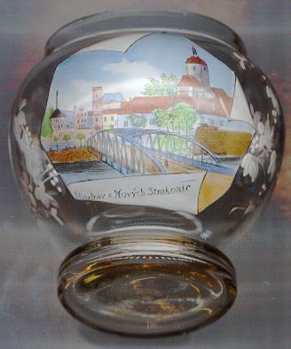
Nové Strakonice (Neu-Strakonitz) [left] today is part of Strakonice.
The church of St. Prokop [left] belongs to the oldest parts of the castle of Strakonice.
The Romanesque-Gothic church was founded in the 13th century and originally was dedicated to St. Vojtìch. The monumental tower
was added to the church in 1714–1722. Parts of the church were modified in Baroque style during the 18th century.
Among the treasures of the church are a Gothic folding altar dating from around 1250
and the so-called Madonna of Strakonice, the original of which is kept in the National Gallery of Prague.
![[scale]](lineal.jpg)