
|
|
| ÖSTERREICH | AUSTRIA |
| Bundesland: Niederösterreich | Lower Austria |
| Bezirk: Sankt Pölten |
map →

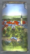 Traismauer is situated at an elevation of 197 m on the river Traisen
southwest of its mouth into the river Danube (the mouth was moved to the east
when the river power plant on the Danube at Altenwörth was built in 1973–76).
Rich archeological finds from around 4000 BC show that the area was already inhabited in prehistoric times.
Situated near the Danube, the northern border of the ancient Roman empire, it was part of an extended
chain of fortifications and was called Augustianis by the Romans.
The first Roman castle is thought to have been built around AD 69–76, the second one about AD 140–143.
In the 9th century (around AD 800) it came into possession of the Diocese of Salzburg.
The Slavic Prince Priwina was baptized here in 833. The foundations of the
Roman buildings of the 3rd and 4th century were used for the medieval settlement
which was enlarged in the 16th century. In 1458 Traismauer became a market town and
since 1958 it has the status of a town.
Traismauer is situated at an elevation of 197 m on the river Traisen
southwest of its mouth into the river Danube (the mouth was moved to the east
when the river power plant on the Danube at Altenwörth was built in 1973–76).
Rich archeological finds from around 4000 BC show that the area was already inhabited in prehistoric times.
Situated near the Danube, the northern border of the ancient Roman empire, it was part of an extended
chain of fortifications and was called Augustianis by the Romans.
The first Roman castle is thought to have been built around AD 69–76, the second one about AD 140–143.
In the 9th century (around AD 800) it came into possession of the Diocese of Salzburg.
The Slavic Prince Priwina was baptized here in 833. The foundations of the
Roman buildings of the 3rd and 4th century were used for the medieval settlement
which was enlarged in the 16th century. In 1458 Traismauer became a market town and
since 1958 it has the status of a town.
The  parish church Sankt Rupert [right]
was built in Late Romanesque style before 1293 and became a parish church in 1359.
Between 1475 and 1500 it was transformed in late Gothic style. The west tower
was heighted in 1656 and in 1764.
parish church Sankt Rupert [right]
was built in Late Romanesque style before 1293 and became a parish church in 1359.
Between 1475 and 1500 it was transformed in late Gothic style. The west tower
was heighted in 1656 and in 1764.
![[scale]](lineal.jpg)