
|
|
| DEUTSCHLAND | GERMANY |
| Bundesland: Freistaat Sachsen | Saxony |
| Landkreis: Mittelsachsen |
map →

 Leisnig is situated at an elevation of 220 m on the river Freiberger Mulde. The first documented defence system at the
site of the later castle Mildenstein had already existed in 936. Emperor Heinrich III gave this site to his wife,
Empress Agnes of Poitou, who made it a royal residence in 1057. The present castle was created in 1081/1083. The town developed
only from 1100 onward about 2 km away at a ford across the river (today Alt-Leisnig, documented as oppidum novum, new town in 1215).
Between 1278 and 1280 the village was transfered to its modern site on an elevated area between the castle and the river.
In 1147, the burgraviate of Leisnig came into possession of Duke Friedrich III of Swabia, the later Emperor Friedrich I (Barbarossa),
who made it immediate to the Emperor in 1158. It remained an exclave within the Margraviate of Meißen until 1329,
when Emperor Ludwig IV gave it as a fief to Margrave Wilhelm of Meißen ('the One-Eyed'). During the Thirty Years' War (1618–1648),
Leisnig was looteed several times. During the Nordic War of 1700–1721 Swedish troops occupied large parts of Saxony including Leisnig.
Stanisław I Leszczyński, who was proclaimed King of Poland against Friedrich August I, Elector of Saxony (August II as King of Poland),
resided in Leisnig in 1706/1708 where he also signed the Peace Treaty of Altranstädt, which accepted him as King of Poland.
Leisnig is situated at an elevation of 220 m on the river Freiberger Mulde. The first documented defence system at the
site of the later castle Mildenstein had already existed in 936. Emperor Heinrich III gave this site to his wife,
Empress Agnes of Poitou, who made it a royal residence in 1057. The present castle was created in 1081/1083. The town developed
only from 1100 onward about 2 km away at a ford across the river (today Alt-Leisnig, documented as oppidum novum, new town in 1215).
Between 1278 and 1280 the village was transfered to its modern site on an elevated area between the castle and the river.
In 1147, the burgraviate of Leisnig came into possession of Duke Friedrich III of Swabia, the later Emperor Friedrich I (Barbarossa),
who made it immediate to the Emperor in 1158. It remained an exclave within the Margraviate of Meißen until 1329,
when Emperor Ludwig IV gave it as a fief to Margrave Wilhelm of Meißen ('the One-Eyed'). During the Thirty Years' War (1618–1648),
Leisnig was looteed several times. During the Nordic War of 1700–1721 Swedish troops occupied large parts of Saxony including Leisnig.
Stanisław I Leszczyński, who was proclaimed King of Poland against Friedrich August I, Elector of Saxony (August II as King of Poland),
resided in Leisnig in 1706/1708 where he also signed the Peace Treaty of Altranstädt, which accepted him as King of Poland.
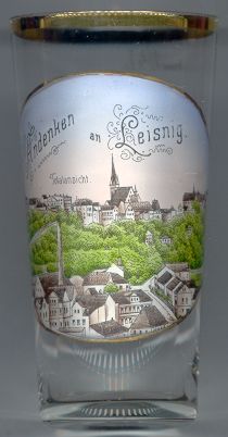
The  church Sankt Matthäi [centre] was first mentioned in a document in 1192.
The present church dates from the second half of the 15th century. After a large fire in 1637, the church eas restored between 1638 and 1646.
church Sankt Matthäi [centre] was first mentioned in a document in 1192.
The present church dates from the second half of the 15th century. After a large fire in 1637, the church eas restored between 1638 and 1646.
![[scale]](lineal.jpg)