
|
|
| DEUTSCHLAND | GERMANY |
| Bundesland: Freistaat Sachsen | Saxony |
| Landkreis: Vogtlandkreis |
map →

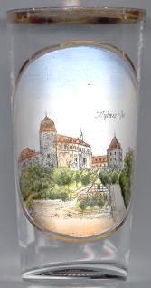 Mylau is situated at an elevation of 290–370 m in the Göltzsch valley. The town developed beneath the
 castle [left] which was founded around 1180.
The estate was first mentioned in a document in 1212 when it was given to Bohemia by Emperor Friedrich II.
Karl IV, Roman Emperor and King of Bohemia, visited Mylau in 1367 and gave it the status of a town.
Since then the coat of arms of the town contains the image of the emperor. The castle was enlarged in Gothic style between 1370 and 1420,
later additions date from the Renaissance and Baroque periods. In 1422 Mylau became part of Saxony.
The castle served as noble residence until 1772. In 1808 it was converted to a cotton-mill.
From 1860 onward Mylau became one of the centres of the textile industry in Saxony. The municipality of Mylau baught the castle in 1892
and used it as town hall, tavern and museum.
Since 1 January 2016, Mylau is part of the municipality Reichenbach im Vogtland.
castle [left] which was founded around 1180.
The estate was first mentioned in a document in 1212 when it was given to Bohemia by Emperor Friedrich II.
Karl IV, Roman Emperor and King of Bohemia, visited Mylau in 1367 and gave it the status of a town.
Since then the coat of arms of the town contains the image of the emperor. The castle was enlarged in Gothic style between 1370 and 1420,
later additions date from the Renaissance and Baroque periods. In 1422 Mylau became part of Saxony.
The castle served as noble residence until 1772. In 1808 it was converted to a cotton-mill.
From 1860 onward Mylau became one of the centres of the textile industry in Saxony. The municipality of Mylau baught the castle in 1892
and used it as town hall, tavern and museum.
Since 1 January 2016, Mylau is part of the municipality Reichenbach im Vogtland.
The famous Göltzsch valley bridge, located between Mylau and Netzschkau (for a souvenir glass with a picture of the bridge see
there), is a technical and historical landmark. It was built in 1846–1851 for the railway line from
Leipzig to Hof in Bavaria. Its height of 78 m made it the highest railway bridge of its time.
Its dimensions (length 574 m, maximum span width 30.9 m) still make it the world's largest brick bridge.
![[scale]](lineal.jpg)