
|
|
| DEUTSCHLAND | GERMANY |
| Bundesland: Baden-Württemberg | |
| Regierungsbezirk: Tübingen | |
| Landkreis: Alb-Donau-Kreis |
map →

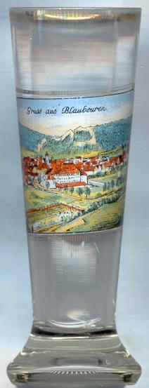 Blaubeuren is situated at an elevation of 513 m on the river Blau in the Donau-Alb region of Baden-Württemberg.
Archeological finds document settlements going back to about 15,000 BC The first Christian church, the chapel of St. John the Baptist
at the source of the river, the 'Blautopf', goes back to the 10th century and became the place where the monastery of Blaubeuren
was founded in 1085. Blaubeuren was first mentioned as a free town in 1267. From 1303 it was an Austrian fief until 1447 when it was sold to Württemberg.
For a long time it remained the southern-most property of Württemberg. Only in 1635–1648 it was occupied again by Austria, and in 1688 by the French.
The town's coat of arms with the figure of the 'Blaumännle' was granted by Emperor Friedrich III in 1471.
During the Reformation Blaubeuren became protestant in 1534; the former Benedictine monastery became protestant in 1562.
Nevertheless, Blaubeuren also remained a catholic Marian pilgrimage site. The monastery and the town were administered
separately, and both had their own walls, separated by the town moat. A small foot-path led from the monastery to a small gate in the town wall.
Only around 1600 a larger gate was built. However, at that time the monastery as such did not exist any more. The administration
of the former monastery still remained separate from that of the town until 1807.
Blaubeuren is situated at an elevation of 513 m on the river Blau in the Donau-Alb region of Baden-Württemberg.
Archeological finds document settlements going back to about 15,000 BC The first Christian church, the chapel of St. John the Baptist
at the source of the river, the 'Blautopf', goes back to the 10th century and became the place where the monastery of Blaubeuren
was founded in 1085. Blaubeuren was first mentioned as a free town in 1267. From 1303 it was an Austrian fief until 1447 when it was sold to Württemberg.
For a long time it remained the southern-most property of Württemberg. Only in 1635–1648 it was occupied again by Austria, and in 1688 by the French.
The town's coat of arms with the figure of the 'Blaumännle' was granted by Emperor Friedrich III in 1471.
During the Reformation Blaubeuren became protestant in 1534; the former Benedictine monastery became protestant in 1562.
Nevertheless, Blaubeuren also remained a catholic Marian pilgrimage site. The monastery and the town were administered
separately, and both had their own walls, separated by the town moat. A small foot-path led from the monastery to a small gate in the town wall.
Only around 1600 a larger gate was built. However, at that time the monastery as such did not exist any more. The administration
of the former monastery still remained separate from that of the town until 1807.
The 'Blautopf' is one of the major tourist attractions of Blaubeuren. With a depth of 21 m it is one of the deepest
and largest river sources of Germany, supplying between 310 and up to 32,000 litres of water per second. An underwater system of caves extending
more than 1 km was discovered in 1985.
![[scale]](lineal.jpg)