
|
|
If you came to this page directly and do not see a navigation frame on top, please go to the home page.
| DEUTSCHLAND | GERMANY |
| Bundesland: Freistaat Sachsen | Saxony |
| Landkreis: Erzgebirgskreis |
map →

 Aue is situated at an elevation of 438 m at the confluence of the river Schwarzwasser into the Freiberger Mulde in western Saxony.
The municipality has a population of about 19,000 (2002).
Aue is situated at an elevation of 438 m at the confluence of the river Schwarzwasser into the Freiberger Mulde in western Saxony.
The municipality has a population of about 19,000 (2002).
The earliest mention of Aue dates back to 1526. In 1627 it obtained the right to hold two annual fairs and in 1632 it
received the status of a free town. The town was completely destroyed in 1633 during the Thirty Years' War. Starting in
1698/1709, kaolin was mined in Aue and was used by Johann Friedrich Böttger to produce the first white china porcelain of Europe.
During the Seven Years' War Aue was again destroyed during a battle between Prussian and Austrian troops. The industrial development
was boosted by the opening of two railway lines through Aue in 1858 and 1875, respectively. After that, Aue developed into the most important
industrial site of the Erzgebirge (Ore Mountains) region. The village of Zelle, which already had been mentioned in a document of 1173, became part
of Aue in 1897. Since then the year 1173 is used for calculating anniversaries of Aue.
The districts Aue and Schwarzenberg were merged in 1994. Aue became the seat of the the new district,
which at first was named Westerzgebirgskreis. In 1995 the district was renamed Aue-Schwarzenberg. On 1st August 2008 the districts Annaberg,
Aue-Schwarzenberg, Mittlerer Erzgebirgskreis and Stollberg were merged to become the new district Erzgebirgskreis with the seat of the district's
administration in Annaberg-Buchholz.
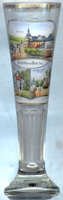
The  Stadthaus ('townhouse') [left, no. 1902: top picture] was built in the year 1900.
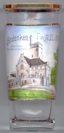
The König-Friedrich-August-Warte [left, no. 1902: bottom left picture, and right, no. 804] was planned
by citizens of Aue beginning in 1895.
The park was designed on an inclined area at the bank of the river Mulde. The municipality donated further land in 1902.
The lookout tower itself was built in 1904/1905 and was named for Friedrich August III, the last King of Saxony (b.1865, acc.1904, abd.1918,d.1932).
The bottom right picture on glass no. 1902 [left] shows the
King
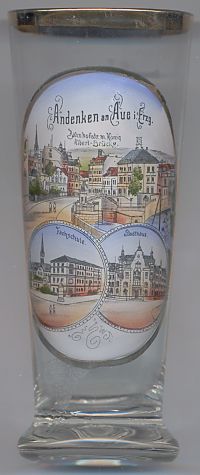
The top picture on glass no. 2318 [left] shows a view of
Bahnhofstraße König-Albert-Brücke
The bottom left picture shows a view of the
Fachschule
The bottom right picture shows a view of the
Stadthaus
![[scale]](lineal.jpg)