
|
|
| ÖSTERREICH | AUSTRIA |
| Bundesland: Niederösterreich | Lower Austria |
| Bezirk: Horn |
map →

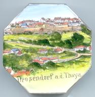
 Drosendorf is situated at an elevation of 423 m on the river Thaya in the northern Waldviertel region of
Lower Austria close to the border to the Czech Republic. Drosendorf is part of the municipality
Drosendorf-Zissersdorf, which has a population of about 1,300 (2001).
Drosendorf is situated at an elevation of 423 m on the river Thaya in the northern Waldviertel region of
Lower Austria close to the border to the Czech Republic. Drosendorf is part of the municipality
Drosendorf-Zissersdorf, which has a population of about 1,300 (2001).
 The first mention in a document dates from 1188 AD. The town was laid out as a fortified border town on a rocky hill above the river in the 12th century.
Most parts of the fortifications, which were enlarged in the 16th and 17th century, are still preserved. Already in 1255, Drosendorf seems to have had the status of a town.
A town charter existed already in 1310, and was renewed in 1399. New privileges were granted in 1559 and 1560.
The first mention in a document dates from 1188 AD. The town was laid out as a fortified border town on a rocky hill above the river in the 12th century.
Most parts of the fortifications, which were enlarged in the 16th and 17th century, are still preserved. Already in 1255, Drosendorf seems to have had the status of a town.
A town charter existed already in 1310, and was renewed in 1399. New privileges were granted in 1559 and 1560.
The  parish church Sankt Peter und Paul [top right, barely visible]
was first mentioned in 1153. The Gothic church was devastated in 1620 and 1645 and was rebuilt in Baroque style.
The tabernacle dates from around 1515.
parish church Sankt Peter und Paul [top right, barely visible]
was first mentioned in 1153. The Gothic church was devastated in 1620 and 1645 and was rebuilt in Baroque style.
The tabernacle dates from around 1515.
![[scale]](lineal.jpg)