
|
|
| ÖSTERREICH | AUSTRIA |
| Bundesland: Steiermark | Styria |
| Bezirk: Deutschlandsberg |
map →

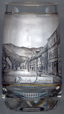 Deutschlandsberg is situated at an elevation of 368 m on the river Laßnitz at the foot of the Koralpe mountain area.
The place began to develop below the castle Landsberg, which received its name from the noble Lonspercher family.
Lonsperch was first mentioned in a document of 1153. During the 18th century, the name Landsberg slowly changed to Deutsch (German) Landsberg
(1774 Teutschlandsberg, 1789 Teitsch Landsperg, 1799 Deutsch Landsberg) in order to distinguish the town from another place called Landsberg in the
southern, Slovene part of the Duchy of Styria, Windischlandsberg (today Podčetrtek in Slovenia). Deutschlandsberg became the official name in 1822.
Although the document of 1278 where King Rudolf I of Habsburg granted the rights of a market town proved to be a fake, it is certain that
Deutschlandsberg obtained this status around 1280. In the last year of the Austrian monarchy, in 1918, Deutschlandsberg received the status of a town from
Austria's last Emperor, Karl I.
Deutschlandsberg is situated at an elevation of 368 m on the river Laßnitz at the foot of the Koralpe mountain area.
The place began to develop below the castle Landsberg, which received its name from the noble Lonspercher family.
Lonsperch was first mentioned in a document of 1153. During the 18th century, the name Landsberg slowly changed to Deutsch (German) Landsberg
(1774 Teutschlandsberg, 1789 Teitsch Landsperg, 1799 Deutsch Landsberg) in order to distinguish the town from another place called Landsberg in the
southern, Slovene part of the Duchy of Styria, Windischlandsberg (today Podčetrtek in Slovenia). Deutschlandsberg became the official name in 1822.
Although the document of 1278 where King Rudolf I of Habsburg granted the rights of a market town proved to be a fake, it is certain that
Deutschlandsberg obtained this status around 1280. In the last year of the Austrian monarchy, in 1918, Deutschlandsberg received the status of a town from
Austria's last Emperor, Karl I.
The  Plague Column or Lady Column was erected in 1711 on the square Unterer Platz
as a sign of gratefulness that Deutschlandsberg was saved from the plague in 1655. Today, the column is situated on the Hauptplatz (Main square) [background left, barely visible].
Plague Column or Lady Column was erected in 1711 on the square Unterer Platz
as a sign of gratefulness that Deutschlandsberg was saved from the plague in 1655. Today, the column is situated on the Hauptplatz (Main square) [background left, barely visible].
![[scale]](lineal.jpg)