
|
|
| DEUTSCHLAND | GERMANY |
| Bundesland: Freistaat Sachsen | Saxony |
| Landkreis: Nordsachsen |
map →

Dommitzsch is situated at an elevation of 100 m near the river Elbe in northern Saxony at the border to Saxony-Anhalt.
It was first mentioned in documents of around AD 985 (as Dumoz or Dumoki).
For a long time it was a border town at the norther border of the march Meißen.
The first mention as a town dates from 1298. Following the division of Saxony between the Ernestine and the Albertine lines of
Meißen in 1485 Dommitzsch belonged to the Ernestine line. After the Battle of Mühlberg in 1547 it came into possession
of the Albertine line. Dommitzsch became part of the Prussian Province Saxony in 1815.
Between 1945 and 1952 it was part of Saxony-Anhalt, after 1952 it was part of the district of Leipzig.
In 1990 the majority of the population decided in a referendum
to remain part of the newly-established state of Saxony.
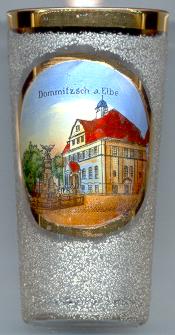

The  Marienkirche (church of Our Lady) [right, background] was built 1443–1493.
Originally, it had two spires, which were destroyed by fire in 1588. Swedish troops set fire in the church during the Thirty Years' War in 1637.
The present tower (height 48 m) was built in 1802.
Marienkirche (church of Our Lady) [right, background] was built 1443–1493.
Originally, it had two spires, which were destroyed by fire in 1588. Swedish troops set fire in the church during the Thirty Years' War in 1637.
The present tower (height 48 m) was built in 1802.
The Town Hall [left] was built in 1910.
![[scale]](lineal.jpg)