
|
|
| DEUTSCHLAND | GERMANY |
| Bundesland: Niedersachsen | Lower Saxony |
| Landkreis: Aurich |
map →
The island of Juist is only 500 m wide, but 17 km long, which makes it the longest of the East Frisian Islands (Borkum, Memmert, Juist, Norderney, Baltrum, Langeoog, Spiekeroog and Wangerooge). 2,800 people live on the island. No motor traffic is allowed.
 The earliest mentin of the island dates from 1398 when the island was part of the domains of the chieftain family
tom Brook. Before, the name Just refered to a settlement on the large island of Bant. It is not known exactly
when Bant was broken up by storms, forming eventually the modern island of Juist. In the 15th century the island came
under the influence of the East Frisian counts and princes of the Cirksena family. The 'St. Peter's Flood' of 1651
broke through the northern edge dunes in the area of the present-day Hammersee and divided the island into two roughly equal
parts. After the Peace of Tilsit in 1807, East Frisia and thus Juist became part of the French
Kingdom of Holland. French occupation troops stayed on the island from 1811 until 1816 when the island was returned to the
Kingdom of Hannover. Together with Hannover, the east Frisian islands were annexed by the
kingdom of Prussia in 1866. By 1870 the southern part of the sea branch between the two parts of the island ('Hammer bay')
had been secured by a dam. The first jetty was built in 1894. A horse railway was built on the island in 1898 but was
destroyed in the same year by a storm. The line was reconstructed and reopened in 1899 as Germany's first island railway
using steam engines. The northern part of the Hammer bay was closed by a dam in 1928–1932. A storm flood in 1932
filled the low-lying area between the dams with water and created today's Hammer lake. Within the course of the century
the brackish waters of the lake finally turned to freshwater.
The earliest mentin of the island dates from 1398 when the island was part of the domains of the chieftain family
tom Brook. Before, the name Just refered to a settlement on the large island of Bant. It is not known exactly
when Bant was broken up by storms, forming eventually the modern island of Juist. In the 15th century the island came
under the influence of the East Frisian counts and princes of the Cirksena family. The 'St. Peter's Flood' of 1651
broke through the northern edge dunes in the area of the present-day Hammersee and divided the island into two roughly equal
parts. After the Peace of Tilsit in 1807, East Frisia and thus Juist became part of the French
Kingdom of Holland. French occupation troops stayed on the island from 1811 until 1816 when the island was returned to the
Kingdom of Hannover. Together with Hannover, the east Frisian islands were annexed by the
kingdom of Prussia in 1866. By 1870 the southern part of the sea branch between the two parts of the island ('Hammer bay')
had been secured by a dam. The first jetty was built in 1894. A horse railway was built on the island in 1898 but was
destroyed in the same year by a storm. The line was reconstructed and reopened in 1899 as Germany's first island railway
using steam engines. The northern part of the Hammer bay was closed by a dam in 1928–1932. A storm flood in 1932
filled the low-lying area between the dams with water and created today's Hammer lake. Within the course of the century
the brackish waters of the lake finally turned to freshwater.
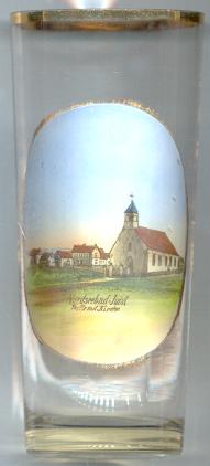
The first church on the island was destroyed by high tides in 1651, and three later churches also were destroyed by the sea.
The picture on the glass shows Juist's  fifth church
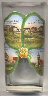
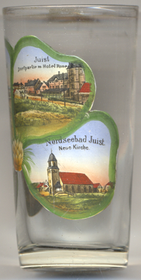 Hotel Kurhaus [near left, no. 3807: top left]
was built in 1898. Alterations followed soon, especially after the storm flood of 1906. All in all, the exterior appearance
of the hotel, with the exception of a balcony above the main entrance and window gables that have been removed, has not
changed since then.
Hotel Kurhaus [near left, no. 3807: top left]
was built in 1898. Alterations followed soon, especially after the storm flood of 1906. All in all, the exterior appearance
of the hotel, with the exception of a balcony above the main entrance and window gables that have been removed, has not
changed since then.
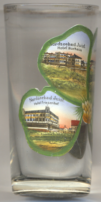
The top right picture on glass no. 3807 shows a view of
Hotel Rose
Hotel Friesenhof [near left, no. 3807: bottom left]
opened in 1901. The hotel was enlarged in 1928.
The bottom right picture on glass no. 3807 shows the new (fifth) church as it appeared after the west tower
had been built in 1908 (see above).
[https://de.wikipedia.org/wiki/Juist, https://en.wikipedia.org/wiki/Juist;
https://de.wikipedia.org/wiki/Inselkirche_Juist;
https://www.strandhotel-kurhaus-juist.com/unser-hotel/historie.html;
https://www.wikiwand.com/de/Zu_den_heiligen_Schutzengeln_(Juist)#/Geschichte;
https://friesenhof.info/hotel-juist/geschichte/]
![[scale]](lineal.jpg)