
|
|
| ČESKÁ REPUBLIKA | CZECH REPUBLIC |
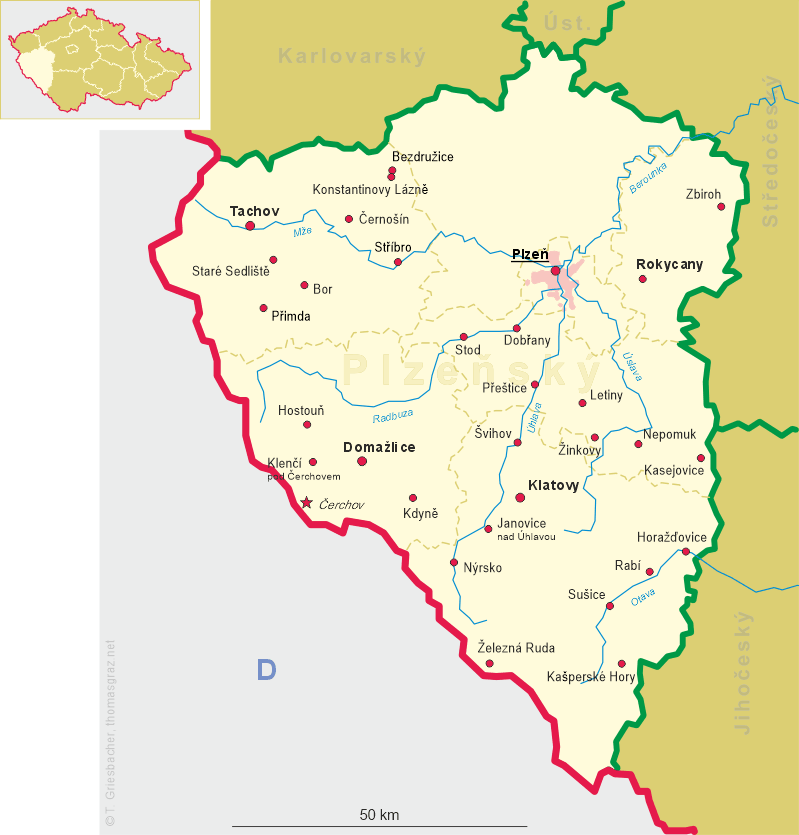
| Plzeňský kraj | Plzeň region |
| Okres: Klatovy |
map →
 Nýrsko is situated in the valley of the river Úhlava (German: Angel) in Southern West Bohemia.
The village began to develop at a ford across the river, and was first mentioned in a document in 1327.
At first the settlement consisted of two separate parts: Horní Nýrsko (Oberneuern) belonged to the lords of castle Pajrek (Beiereck or Bayerck),
Dolní Nýrsko (Unterneuern) belonged to Bystřice nad Úhlavou (Bistritz an der Angel). Both parts were united in 1558. It is not known when exactly
Nýrsko obtained the status of a town, but in 1593 Emperor Rudolf II granted the rights to hold one weekly market and two annual fairs.
Until World War II a Jewish community (first mentioned in the 17th century, 4% of the population in 1930) lived here.
The synagogue from 1734 was demolished by the Nazis in 1939, the large Jewish cemetry in the vicinity of Nýrsko still exists.
Nýrsko is situated in the valley of the river Úhlava (German: Angel) in Southern West Bohemia.
The village began to develop at a ford across the river, and was first mentioned in a document in 1327.
At first the settlement consisted of two separate parts: Horní Nýrsko (Oberneuern) belonged to the lords of castle Pajrek (Beiereck or Bayerck),
Dolní Nýrsko (Unterneuern) belonged to Bystřice nad Úhlavou (Bistritz an der Angel). Both parts were united in 1558. It is not known when exactly
Nýrsko obtained the status of a town, but in 1593 Emperor Rudolf II granted the rights to hold one weekly market and two annual fairs.
Until World War II a Jewish community (first mentioned in the 17th century, 4% of the population in 1930) lived here.
The synagogue from 1734 was demolished by the Nazis in 1939, the large Jewish cemetry in the vicinity of Nýrsko still exists.
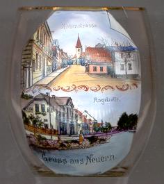
The oldest existing building in Nýrsko is the Gothic  church of St. Thomas [left, top picture, in the background].
The church was first mentioned in 1352. It was enlarged in the 17th century, most of the interior furnishing dates from the 18th century.
church of St. Thomas [left, top picture, in the background].
The church was first mentioned in 1352. It was enlarged in the 17th century, most of the interior furnishing dates from the 18th century.
The two vires are labeled in German Kirchenstraße ('Church Street'; today Klostermannova)
[top] and
Angelzeile ('Úhlava Row'; today Kpt. Kufnera (?)) [bottom].
![[scale]](lineal.jpg)