
|
|
| DEUTSCHLAND | GERMANY |
| Bundesland: Freistaat Bayern | Bavaria |
| Regierungsbezirk: Mittelfranken | |
| Landkreis: Ansbach |
map →

 Rothenburg ob der Tauber is situated at an elevation of 425 m on a plateau some 60 m above the river Tauber, above 30 km
northwest of the district town Ansbach.
Rothenburg ob der Tauber is situated at an elevation of 425 m on a plateau some 60 m above the river Tauber, above 30 km
northwest of the district town Ansbach.
The village of Detwang, today part of Rothenburg, was founded around AD 960. About ten years later, the first stronghold was built. In 1142, King Konrad III built a second castle next to it. Both castles were destroyed by an earthquake in 1356. In 1274, King Rudolf I elevated Rothenburg to a Free Imperial Town, which initiated a period of great prosperity. Rothenburg developed into an important trading town and held a leading place among the powerful cities of Southern Germany. During the Peasants' War, Rothenburg suffered a considerable defeat in 1525. In 1544, the citizens converted to the proetstant faith. During the Thirty Years' War (1618–1848), Rothenburg could evade its destruction, but was reduced to a tiny, insignificant town. The period of Rothenburg's independence ended in 1802, when the town was incorporated into the Kingdom of Bavaria. The well-preserved medieval town became a centre for artists of the Romantic period. Towards the end of World War II, parts of the historic old town were destroyed by a bomb raid. After the war, this part of the town was rebuilt according to the medieval plans.
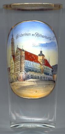
The famous Gothic  town hall [left] with its Imperial Hall and the tower (60 m high) dates
from the period between 1250 and 1400. The front part, in Renaissance style, was built in 1572–1578. The arcades were added in 1681.
town hall [left] with its Imperial Hall and the tower (60 m high) dates
from the period between 1250 and 1400. The front part, in Renaissance style, was built in 1572–1578. The arcades were added in 1681.
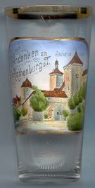
The gatehouse Kobolzeller Tor [near left]
was built in 1360 at the southwestern corner of the town.
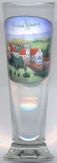
The spa complex Wildbad Rothenburg [near left]
is located at the steep slope of the Tauber valley within the municipality of Rotenburg ob der Tauber.
The complex was built at the end of the 19th century by Friedrich Hessing, the inventor of the orthopedic prosthesis.
Hessing already owned an orthopaedic sanatorium in Göggingen near Augsburg. Wildbad Rothenburg opened in 1903.
The design for the buildings in romantic Historicism style was made by the architect Jean Keller who already had
drawn the plans for the sanatorium at Göggingen. The spa was forced to close already in 1917.
During the 20th century, the complex served a viariety of purposes. In 1978 it was sold to the
Evangelical Lutheran Church in Bavaria which now runs it a convention centre.
![[scale]](lineal.jpg)