
|
|
| ÖSTERREICH | AUSTRIA |
| Bundesland: Steiermark | Styria |
| Bezirk: Leoben |
map →

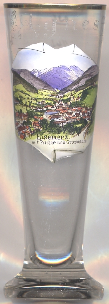
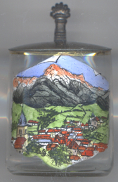
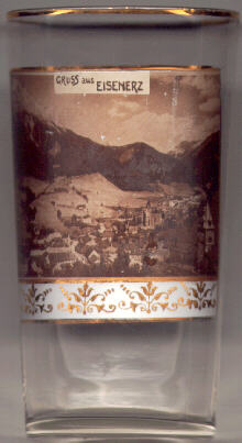 Eisenerz, situated at an elevation of 730 m amidst the mountains
Pfaffenstein (1,871 m), Kaiserschild (2,084 m) and Erzberg (1,466 m),
has a history of iron mining and iron smelting that goes back for centuries.
The wealth of the town always was based on the iron mined at the nearby Erzberg.
Iron smelted in Eisenerz was then transported along the so-called Eisenstraße (Iron Road)
to Steyr in Upper Austria.
The name Eisenerz (literally 'iron ore') first appeared in a document of 1294 (Eysenärtz),
but the older name Innerberg also remained in use officially until the 18th century. In recent years tourism has become more and more
important for the town, especially since (underground) mining on the Erzberg was stopped.
Eisenerz, situated at an elevation of 730 m amidst the mountains
Pfaffenstein (1,871 m), Kaiserschild (2,084 m) and Erzberg (1,466 m),
has a history of iron mining and iron smelting that goes back for centuries.
The wealth of the town always was based on the iron mined at the nearby Erzberg.
Iron smelted in Eisenerz was then transported along the so-called Eisenstraße (Iron Road)
to Steyr in Upper Austria.
The name Eisenerz (literally 'iron ore') first appeared in a document of 1294 (Eysenärtz),
but the older name Innerberg also remained in use officially until the 18th century. In recent years tourism has become more and more
important for the town, especially since (underground) mining on the Erzberg was stopped.
The  parish church Sankt Oswald [center right]
was first mentioned in a document of 1282. The present church dates from the
late 15th and early 16th century. Additions of the Baroque era were removed
during the renovation of 1890–1899. In the times of the Turkish invasions the
church was fortified: the earliest parts date from 1482, while most parts of the
fortification date from 1532–1534. St. Oswald is the largest fortified church
in Styria.
parish church Sankt Oswald [center right]
was first mentioned in a document of 1282. The present church dates from the
late 15th and early 16th century. Additions of the Baroque era were removed
during the renovation of 1890–1899. In the times of the Turkish invasions the
church was fortified: the earliest parts date from 1482, while most parts of the
fortification date from 1532–1534. St. Oswald is the largest fortified church
in Styria.
The mountains identified on glass no. 2732 [left] are
the Polster Griesmauer Pfaffenstein
![[scale]](lineal.jpg)