
|
|
| ÖSTERREICH | AUSTRIA |
| Bundesland: Niederösterreich | Lower Austria |
| Bezirk: Wiener Neustadt |
map →

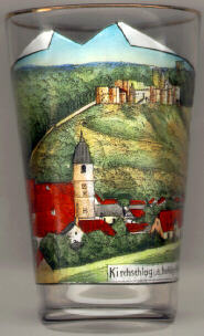 The market town Kirchschlag in der Buckligen Welt is situated at an elevation of 414 m in the valley of the Zöbernbach stream in the
Bucklige Welt ('Humpy World') mountain region of southeast Lower Austria.
The market town Kirchschlag in der Buckligen Welt is situated at an elevation of 414 m in the valley of the Zöbernbach stream in the
Bucklige Welt ('Humpy World') mountain region of southeast Lower Austria.
The  castle [top right] dates back to the 12th century. It was conquered by King Béla IV
of Hungary in 1246, by King Matthias Corvinus in 1483, and was evacuated in 1491.
The castle was rebuilt in the 16th century, but destroyed in 1683.
castle [top right] dates back to the 12th century. It was conquered by King Béla IV
of Hungary in 1246, by King Matthias Corvinus in 1483, and was evacuated in 1491.
The castle was rebuilt in the 16th century, but destroyed in 1683.
The fortified parish church Sankt Johannes der Täufer (St. John the Baptist) [bottom left]
was built in 1480–1500 in late Gothic style with a stellar rib vaulting and fine tracery windows. The roof of the west tower was altered in the Baroque period.
A fresco depicting St. Christophorus dates from the 16th century.
![[scale]](lineal.jpg)