
|
|
| ÖSTERREICH | AUSTRIA |
| Bundesland: Niederösterreich | Lower Austria |
| Bezirk: Mödling |
map →

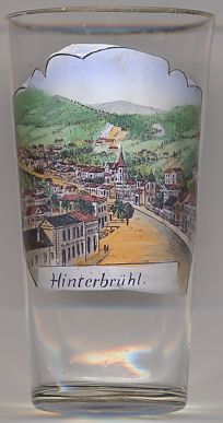
 The market town Hinterbrühl is situated at an elevation of 254 m in the narrow valley called "Brühl" formed by the Mödlingbach stream in the southern
part of the Wienerwald (Vienna Woods). It is a popular day-trip destination and residential area, well-known for its Seegrotte, a grotto in a former gypsum mine that was
closed when water filled parts of the caves. The lake in the grotto is the largest subterranean lake in Europe (6,200 m²) and is navigable with motorboats.
Between 1945 and 1945, the caves were pumped dry and had to serve as an airplane factory.
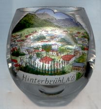
The market town Hinterbrühl is situated at an elevation of 254 m in the narrow valley called "Brühl" formed by the Mödlingbach stream in the southern
part of the Wienerwald (Vienna Woods). It is a popular day-trip destination and residential area, well-known for its Seegrotte, a grotto in a former gypsum mine that was
closed when water filled parts of the caves. The lake in the grotto is the largest subterranean lake in Europe (6,200 m²) and is navigable with motorboats.
Between 1945 and 1945, the caves were pumped dry and had to serve as an airplane factory.
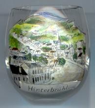
The  parish church Heiliger Johannes der Täufer (St. John the Baptist) [centre background] was built in 1831 in Classicist style, and was enlarged in 1959/60.
![[scale]](lineal.jpg)