
|
|
| DEUTSCHLAND | GERMANY |
| Bundesland: Baden-Württemberg | |
| Regierungsbezirk: Stuttgart | |
| Stadt: Heilbronn |
map →

 Heilbronn is situated at an elevation of 157 m on the river Neckar. Helibrunna was first mentioned in 741.
It obtained the status of a market town in 1146, and that of a town in 1281. From 1371 until 1802 it was a free Imperial City.
The town became protestant in 1530. During the Thirty Years' War Heilbronn formed an alliance with Sweden (Heilbronner Konvent, 1633).
A first period of prosperity during the second half of the 18th century ended with the occupation by the Württemberg troops in 1802, which also
terminated Heilbronn's status as an Imperial City. During the 19th century the town began to flourish again, and at the end of the century
was the second-most important industrial centre of Württemberg. During World War II 80% of the town were destroyed during an allied bomb raid in 1944.
Soon after the war the town was rebuilt. Today Heilbronn has a population of about 120,000 inhabitants.
Heilbronn is situated at an elevation of 157 m on the river Neckar. Helibrunna was first mentioned in 741.
It obtained the status of a market town in 1146, and that of a town in 1281. From 1371 until 1802 it was a free Imperial City.
The town became protestant in 1530. During the Thirty Years' War Heilbronn formed an alliance with Sweden (Heilbronner Konvent, 1633).
A first period of prosperity during the second half of the 18th century ended with the occupation by the Württemberg troops in 1802, which also
terminated Heilbronn's status as an Imperial City. During the 19th century the town began to flourish again, and at the end of the century
was the second-most important industrial centre of Württemberg. During World War II 80% of the town were destroyed during an allied bomb raid in 1944.
Soon after the war the town was rebuilt. Today Heilbronn has a population of about 120,000 inhabitants.
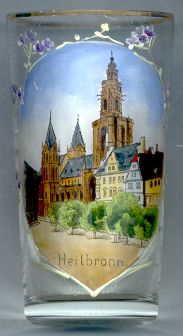
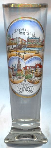
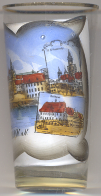
The  church of Sankt Kilian [left, no. 1087: bottom left picture, background, and right, no. 1539]
was built in Gothic style in the second half of the 15th century. The west tower, the first Renaissance tower north of the Alps, was completed in 1529.
The important Late Gothic main altar dates from 1498.
church of Sankt Kilian [left, no. 1087: bottom left picture, background, and right, no. 1539]
was built in Gothic style in the second half of the 15th century. The west tower, the first Renaissance tower north of the Alps, was completed in 1529.
The important Late Gothic main altar dates from 1498.
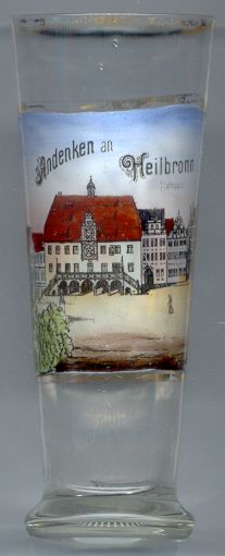
The Town Hall [below, nos.1553 and 1113] was built in 1417 in Gothic style, and was enlarged in Renaissance style at
the end of the 16th century. The elaborate astronomical clock was created in 1579/80. The town hall was destroyed in 1944
and was rebuilt as a copy of the original in 1950–1953.
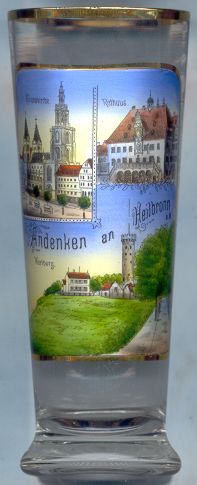
The Wartberg [left, no. 2046: bottom], 308 m, is a popular excursion place.
The old lookout tower goes back to at least the 15th century.
The inn next to the lookout tower goes back to 1792. In 1868 the tower was heightened and received the platform with its
characteristic Neo-Gothic battlements. During World War II the tower was damaged but was restored in the 1950s.
 The Neckar bridge shown on glass no. 3085 [far left] was
built in 1867. It replaced a wooden bridge of 1807, which in turn replaced a wooden bridge dating from 1691 that
was built after a stone bridge built in 1464–1471. The latter had replaced a wooden bridge of around 1349.
[https://stadtarchiv.heilbronn.de/stadtgeschichte/geschichte-a-z/b/bruecke.html?L=2]
The Neckar bridge shown on glass no. 3085 [far left] was
built in 1867. It replaced a wooden bridge of 1807, which in turn replaced a wooden bridge dating from 1691 that
was built after a stone bridge built in 1464–1471. The latter had replaced a wooden bridge of around 1349.
[https://stadtarchiv.heilbronn.de/stadtgeschichte/geschichte-a-z/b/bruecke.html?L=2]
The Hauptpostamt [left, no. 3085: centre]
was built in 1874 1876. The picture on glass no. 3085 only show the two small turrets on the building's
corners. A third tower (not depicted on the glass) was added in the middle of the façade in 1901 and
served the new telecommunication. The building was destroyed on 4 December 1944 during a bomb raid.
[https://de.wikipedia.org/wiki/Postgeschichte_von_Heilbronn,
https://de.wikipedia.org/wiki/Liste_der_abgegangenen_Heilbronner_Gebäude_und_Denkmäler]
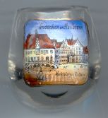
The Kätchenhaus [left, no. 3085: bottom left inset]
is a locate on the corner of Marktplatz and Kaiserstraße. It was built as a private house in the 14th
century. The current name Kätchenhaus was coined only in the 19th century; before that it was mostly
simply called Steinhaus because, unlike most other building of the town, it was entirely built of stone.
The current name alludes to the, fictitious, figure of Kätchen in Heinrich von Kleist's play
Kätchen von Heilbronn. The building was severely damaged during a bomb raid on 4 December 1944,
only the stone façade remained. The structure was rebuilt until 1949 using a simplified plan for the
gabled roof.
[https://de.wikipedia.org/wiki/Käthchenhaus_(Heilbronn)]
The two pictures on the right of glass no. (top and bottom) show views of the church of St. Kilian
and of the town hall, both already described further above.
![[scale]](lineal.jpg)