
|
|
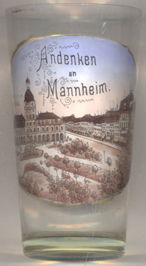
| DEUTSCHLAND | GERMANY |
| Bundesland: Baden-Württemberg | |
| Regierungsbezirk: Karlsruhe | |
| Stadt: Mannheim |
map →

 Mannheim is situated at the confluence of the rivers Neckar and Rhine. It was first mentioned in the "Codex Laureshamensis" of AD 766.
Since 1284 it was in possession of the count palatines from the Wittelsbach dynasty. Mannheim became an important
toll station and soon ranked among the most important places in the Palatinate (Pfalz). Count Palatine Ottheinrich converted to the Protestant faith in 1556.
The castle Friedrichsburg and the new town, laid out after a regular, rectangular plan, were founded by Elector Friedrich II in 1606.
One year later, Mannheim obtained the first town privileges. During the Thirty Years's War (1618–1648), Mannheim was occupied and destroyed several times.
When Count Palatine Philipp Wilhelm of the catholic line of Pfalz-Neuburg inherited Mannheim, catholics were again allowed to be elected into the town council.
Elector Carl Philipp (1716–1742) moved his residence from Heidelberg to Mannheim and began to build the impressive Baroque residence (1720–1760).
A time of prosperity began under Elector Carl Theodor. However, Mannheim lost much of its importance when Carl Theodor moved the residence to
Munich in 1778 after he had become Elector of Bavaria in 1777. During the times of the Napoleonic wars, Mannheim became part of the Grand Duchy of Baden in 1802.
During the 19th century, the industrial and economic development of the town boomed after the river harbours were enlarged in 1834–1840 and 1885–1887.
Large parts of the historic town were destroyed by air raids during World War II.
Mannheim is situated at the confluence of the rivers Neckar and Rhine. It was first mentioned in the "Codex Laureshamensis" of AD 766.
Since 1284 it was in possession of the count palatines from the Wittelsbach dynasty. Mannheim became an important
toll station and soon ranked among the most important places in the Palatinate (Pfalz). Count Palatine Ottheinrich converted to the Protestant faith in 1556.
The castle Friedrichsburg and the new town, laid out after a regular, rectangular plan, were founded by Elector Friedrich II in 1606.
One year later, Mannheim obtained the first town privileges. During the Thirty Years's War (1618–1648), Mannheim was occupied and destroyed several times.
When Count Palatine Philipp Wilhelm of the catholic line of Pfalz-Neuburg inherited Mannheim, catholics were again allowed to be elected into the town council.
Elector Carl Philipp (1716–1742) moved his residence from Heidelberg to Mannheim and began to build the impressive Baroque residence (1720–1760).
A time of prosperity began under Elector Carl Theodor. However, Mannheim lost much of its importance when Carl Theodor moved the residence to
Munich in 1778 after he had become Elector of Bavaria in 1777. During the times of the Napoleonic wars, Mannheim became part of the Grand Duchy of Baden in 1802.
During the 19th century, the industrial and economic development of the town boomed after the river harbours were enlarged in 1834–1840 and 1885–1887.
Large parts of the historic town were destroyed by air raids during World War II.
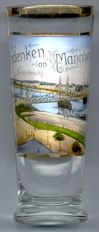
The  Neue Neckarbrücke [left, no. 1091], the second bridge across the river Neckar, was completed in 1877.
Like all other bridges across the river, the historical bridge was blown up by German troops in 1945.
Neue Neckarbrücke [left, no. 1091], the second bridge across the river Neckar, was completed in 1877.
Like all other bridges across the river, the historical bridge was blown up by German troops in 1945.
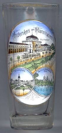
The Hauptbahnhof (Central Station) [left, no. 1953: top picture]
was built in 1871–1876 as a replacement for the older Tattersall station.
The old Kaufhaus in Paradeplatz (Parade Square) [left, no. 1953: bottom left picture]
was built in the 18th century (prior to 1770). In 1910 it was converted and became the new town hall.
During World War ;II the building was completely destroyed in 1943.
A new modern town hall (Stadthaus) was built in its place in 1991.
The Friedrichspark [left, no. 1953: bottom right right picture]
was created in 1882. Parts of the park were used for
the construction of a skate and ice rink, which was destroyed in World War II. A new ice stadium
was built in 1948.
The two buildings in the background are the
observatory Jesuit church St. Ignatius
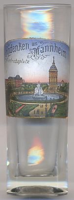 The square, Friedrichsplatz [near left, no. 2259], was created in 1906/1907
for the 300th anniversary of the city.
The water
The square, Friedrichsplatz [near left, no. 2259], was created in 1906/1907
for the 300th anniversary of the city.
The water
 The Festhalle Rosengarten was built in 1900–1903 in Art Nouveau style by the architect Bruno Schmitz.
At a capacity of 6,000 seats it was at the time one of the largest event halls in Germany. It is located at the northern side of
Friedrichsplatz, opposite of Mannheim's landmark, the water tower (see above). During World War II it suffered heava damages. After the
war, the front part was renovated, while the back part was replaced by a modern building. A further enlargement took place in 2006/2007.
The Festhalle Rosengarten was built in 1900–1903 in Art Nouveau style by the architect Bruno Schmitz.
At a capacity of 6,000 seats it was at the time one of the largest event halls in Germany. It is located at the northern side of
Friedrichsplatz, opposite of Mannheim's landmark, the water tower (see above). During World War II it suffered heava damages. After the
war, the front part was renovated, while the back part was replaced by a modern building. A further enlargement took place in 2006/2007.
[https://de.wikipedia.org/wiki/Rosengarten_(Mannheim)]
 The Altes Kaufhaus [near left, no. 3360] in Mannheim's rectangle N 1
was built in 1745. The Baroque building was built in the typical 'Mannheim Symmetry', i.e. two symmetrical buildings
joined together by a central tower. Contrary to its popular name, Altes Kaufhaus ('Old Department Store'),
it was used for commmercial purposes only for a short while; already in the 18th century, it was used for government
offices. From 1903 onward it was in possession of the City of Mannheim, which converted it to be used as the
New Town Hall. During World War II the building was partly destroyed. In order to replace it by a new structure,
a first architectural competition was held in 1960. As a results of this competition, the remainders of the Baroque structure
were torn in order to make way for a planned 60-m-high building. However, funding difficulties caused the cessation of the
construction works in 1968. A second competition was held in competition; however, the winning project also was never
realised. The final, third competition was held in 1986 and resulted in the construction of the present Stadthaus
('City Hall'), a post-modern structure with references to the shape of the Baroque predecessor building.
The Altes Kaufhaus [near left, no. 3360] in Mannheim's rectangle N 1
was built in 1745. The Baroque building was built in the typical 'Mannheim Symmetry', i.e. two symmetrical buildings
joined together by a central tower. Contrary to its popular name, Altes Kaufhaus ('Old Department Store'),
it was used for commmercial purposes only for a short while; already in the 18th century, it was used for government
offices. From 1903 onward it was in possession of the City of Mannheim, which converted it to be used as the
New Town Hall. During World War II the building was partly destroyed. In order to replace it by a new structure,
a first architectural competition was held in 1960. As a results of this competition, the remainders of the Baroque structure
were torn in order to make way for a planned 60-m-high building. However, funding difficulties caused the cessation of the
construction works in 1968. A second competition was held in competition; however, the winning project also was never
realised. The final, third competition was held in 1986 and resulted in the construction of the present Stadthaus
('City Hall'), a post-modern structure with references to the shape of the Baroque predecessor building.
Some further facts:
Friedrich Schiller's play "die Räuber" had its first night at the National Theatre of Mannheim in 1782.
Karl von Drais constructed the first 'running machine', a forerunner of the bicycle, in 1817.
His first ride took him from Mannheim to Schwetzingen.
In 1819, the student Karl Ludwig Sand assassinated the writer and Russian privy councillor August von Kotzebue.
This caused a series of repressive actions by the German governments.
Carl Benz founded his motor factory in 1883. His first automobile was patented in 1886.
[https://de.wikipedia.org/wiki/Mannheimer_Stadthaus]
![[scale]](lineal.jpg)