
|
|
| DEUTSCHLAND | GERMANY |
| Bundesland: Freistaat Sachsen | Saxony |
| Landkreis: Mittelsachsen |
map →

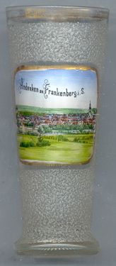 Frankenberg is situated at an elevation of 262 m on the river Zschopau in central Saxony. The place was founded at the end of the 12th
century (most probably in 1188). Due to iron and silver mining, the place had developed into a town by 1282. Mining was the predominant activity until
about 1500. Later, weaving mills became the predominant economical factor. During the 19th century, the weaving mills had developed into an important
textile industry. From 1842, cigars were produced. Until the end of the German Democratic Republic in 1990, also vehicles were produced.
As Frankenberg was not severely damaged during both World Wars, it could conserve much of its old architecture.
Frankenberg is situated at an elevation of 262 m on the river Zschopau in central Saxony. The place was founded at the end of the 12th
century (most probably in 1188). Due to iron and silver mining, the place had developed into a town by 1282. Mining was the predominant activity until
about 1500. Later, weaving mills became the predominant economical factor. During the 19th century, the weaving mills had developed into an important
textile industry. From 1842, cigars were produced. Until the end of the German Democratic Republic in 1990, also vehicles were produced.
As Frankenberg was not severely damaged during both World Wars, it could conserve much of its old architecture.
 The Protestant
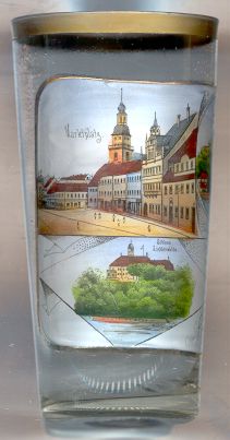
  church Sankt Ägidien (St. Egid) [top left picture: centre] was built in 1741.
The tower was rebuilt in 1874/75.
church Sankt Ägidien (St. Egid) [top left picture: centre] was built in 1741.
The tower was rebuilt in 1874/75.
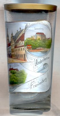
The town hall [left, no. 1219: top left picture: centre right] was built in 1788 and remodelled in 1861.
Lichtenwalde castle [left, no. 1219: bottom left] is located about 3 km from Frankenberg. It was built in 1722–1726
and was remodelled in 1905–1907.
Sachsenburg castle [left, no. 1219: right picture: top] was founded around 1190 and was first mentioned in 1197 (as Sassenberg).
The original, Romanesque, castle was rebuilt in Late Gothic style in 1488. In 1806–1874 it was remodelled, the old castle keep was demolished in 1878.
One of the earliest concentration camps of the Nazis was opened in Sachsenburg in 1933 and operated until 1937.
Today, the village of Sachsenburg is part of Frankenberg.
![[scale]](lineal.jpg)