
|
|
| DEUTSCHLAND | GERMANY |
| Bundesland: Freistaat Bayern | Bavaria |
| Regierungsbezirk: Oberfranken | |
| Landkreis: Bayreuth |
map →

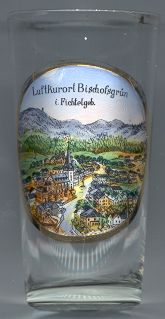 Bischofsgrün is situated at an elevation of 670 m in the heart of the Fichtelgebirge mountain region.
Bischofesgrune was first mentioned in 1242. The tradition of glass-making was first mentioned in 1340, the first
glassworks were mentioned in 1536. Due to its remote location, Bischofgrün was not affected during the Hussite Wars
(1419–1436), the Peasants' War (1525) and the Second Margraves' War (1552–1555), but suffered some damage during
the Thirty Years' War (1618–1648) and the Seven Years' War (1756–1763). The town had to be rebuilt completely
after it had been destroyed by a large fire in 1887. In 1898, Bischofsgrün was connected to the railroad system,
which initiated its tradition as a tourist area (the first skiing club was founded in 1909). The glass industry was revived
after World War II by German emigrants from Gablonz an der Neiße (Jablonec nad Nisou)
in Bohemia. Bischofsgrün was officially recognized as a climatic spa (Luftkurort) in 1952 and in 1992 (heilklimatischer
Kurort).
Bischofsgrün is situated at an elevation of 670 m in the heart of the Fichtelgebirge mountain region.
Bischofesgrune was first mentioned in 1242. The tradition of glass-making was first mentioned in 1340, the first
glassworks were mentioned in 1536. Due to its remote location, Bischofgrün was not affected during the Hussite Wars
(1419–1436), the Peasants' War (1525) and the Second Margraves' War (1552–1555), but suffered some damage during
the Thirty Years' War (1618–1648) and the Seven Years' War (1756–1763). The town had to be rebuilt completely
after it had been destroyed by a large fire in 1887. In 1898, Bischofsgrün was connected to the railroad system,
which initiated its tradition as a tourist area (the first skiing club was founded in 1909). The glass industry was revived
after World War II by German emigrants from Gablonz an der Neiße (Jablonec nad Nisou)
in Bohemia. Bischofsgrün was officially recognized as a climatic spa (Luftkurort) in 1952 and in 1992 (heilklimatischer
Kurort).
The  parish church Sankt Ägidius (St. Egid) [centre left]
was built in 1699–1702.
parish church Sankt Ägidius (St. Egid) [centre left]
was built in 1699–1702.
![[scale]](lineal.jpg)