
|
|
| DEUTSCHLAND | GERMANY |
| Bundesland: Saarland | |
| Landkreis: Saarpfalzkreis |
map →
 Sankt Ingbert is the fifth-largest town of Germany's state of Saarland and is situated at an elevation of 258 m
close to the capital city of Saarbrücken.
The place was first mentioned as Lantolvinga in a document of 888 AD. The name St. Ingbert appears first in the 16th century,
while the name Lendelfingen disappears around 1600. Mining for coal began in 1611, the first iron works were founded in 1732/33.
Between 1795 and 1814, St. Ingbert was part of the French Republic. During this period, in 1797, it formed an independent republic, which however
lasted only for 8 days. In 1816, it became part of the Kingdom of Bavaria. In 1829 St. Ingbert was chartered as a town. By 1859,
it was the most important industrial town of the Palatinate. After the Treaty of Paris (Versailles) in 1919,
St. Ingbert became part of the Saar region in 1920, which was administered under the League of Nations until 1935, and after that became part of
Germany. After World War II, the Saar region became autonomous, but formed a customs union with France between 1947/48 and 1956.
Mining for coal was stopped in 1959.
Sankt Ingbert is the fifth-largest town of Germany's state of Saarland and is situated at an elevation of 258 m
close to the capital city of Saarbrücken.
The place was first mentioned as Lantolvinga in a document of 888 AD. The name St. Ingbert appears first in the 16th century,
while the name Lendelfingen disappears around 1600. Mining for coal began in 1611, the first iron works were founded in 1732/33.
Between 1795 and 1814, St. Ingbert was part of the French Republic. During this period, in 1797, it formed an independent republic, which however
lasted only for 8 days. In 1816, it became part of the Kingdom of Bavaria. In 1829 St. Ingbert was chartered as a town. By 1859,
it was the most important industrial town of the Palatinate. After the Treaty of Paris (Versailles) in 1919,
St. Ingbert became part of the Saar region in 1920, which was administered under the League of Nations until 1935, and after that became part of
Germany. After World War II, the Saar region became autonomous, but formed a customs union with France between 1947/48 and 1956.
Mining for coal was stopped in 1959.
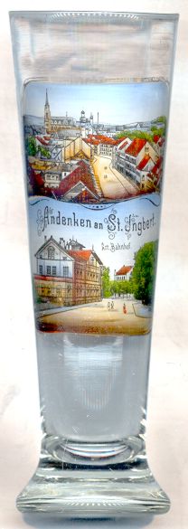
The Catholic  church St. Josef [top picture, background left]
is one of the landmarks of St. Ingbert. The church was built in 1890–1893 in Neo-Gothic style.
church St. Josef [top picture, background left]
is one of the landmarks of St. Ingbert. The church was built in 1890–1893 in Neo-Gothic style.
The lower part of the picture shows the old railway station. St. Ingbert was connected to the
railroad system in 1867.
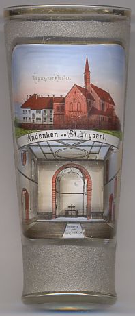
The Capuchin monastery [left]
was founded in 1907, but was dissolved in 1966. The church today serves as church of the parish St. Franziskus.
![[scale]](lineal.jpg)