
|
|
| SLOVENSKO | SLOVAKIA |
| Trenčiansky kraj | Trenčín region |
| okres: Trenčín |
map →
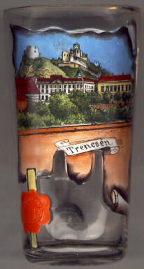 Trenčín is situated at an elevation of 211 m on the river Váh (Hungarian: Vág: German: Waag) on the
eastern foothills of the mountain range Bíle Karpaty (White Carpathians).
A latin inscription on the castle rock dating from 179 AD is probably the oldest
written document in the region of modern Slovakia. The inscription praises the
victory of the Roman legion stationed here in their army camp called Laugaricio
over the Germanic tribe of the Quades. In the 1st half of the 11th century
Trenčín became part of the Kingdom of Hungary. In 1412 it obtained the
status of a free royal town. Today, Trenčín is the economical and industrial
centre of the middle river Váh valley region.
Trenčín has been selected as one of European Capitals of Culture for 2026 (together with Oulu in Finland). [See list of other
European Capitals of Culture depicted on glasses of this collection.]
Trenčín is situated at an elevation of 211 m on the river Váh (Hungarian: Vág: German: Waag) on the
eastern foothills of the mountain range Bíle Karpaty (White Carpathians).
A latin inscription on the castle rock dating from 179 AD is probably the oldest
written document in the region of modern Slovakia. The inscription praises the
victory of the Roman legion stationed here in their army camp called Laugaricio
over the Germanic tribe of the Quades. In the 1st half of the 11th century
Trenčín became part of the Kingdom of Hungary. In 1412 it obtained the
status of a free royal town. Today, Trenčín is the economical and industrial
centre of the middle river Váh valley region.
Trenčín has been selected as one of European Capitals of Culture for 2026 (together with Oulu in Finland). [See list of other
European Capitals of Culture depicted on glasses of this collection.]
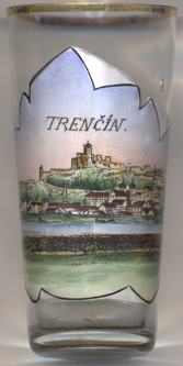
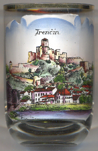
The  castle of Trenčín high on a rock above the
old town, was founded already in the 11th century and was enlarged during the
13th century for the defence of the Váh valley. The main tower (33 m high)
dates from that period. Further enlargements took place in the 15th and 16th century.
The castle was largely destroyed by a fire in 1790 and was subsequently deserted.
In 1954 a major project for the restoration of the castle was started. Today
parts of the district museum are located in the castle.
castle of Trenčín high on a rock above the
old town, was founded already in the 11th century and was enlarged during the
13th century for the defence of the Váh valley. The main tower (33 m high)
dates from that period. Further enlargements took place in the 15th and 16th century.
The castle was largely destroyed by a fire in 1790 and was subsequently deserted.
In 1954 a major project for the restoration of the castle was started. Today
parts of the district museum are located in the castle.
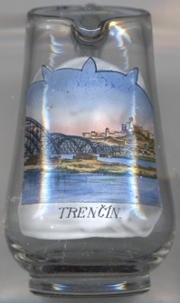
The picture on glass no. 4334 [near left] shows a view of the
old railway bridge
[https://www.vlaky.net/trate/objekt/697/most-viadukt-trencin-most-cez-vah/;
https://www.komoot.com/highlight/349610]
![[scale]](lineal.jpg)