
|
|
| ÖSTERREICH | AUSTRIA |
| Bundesland: Niederösterreich | Lower Austria |
| Bezirk: Waidhofen an der Thaya |
map →


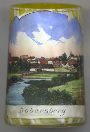 Dobersberg is situated at an elevation of 465 m on the river Thaya in the nature reserve Dobersberg-Thayatal in northern Lower Austria close to the border to the Czech Republic.
Dobersberg was first mentioned in a document of 1112, and by 1230 had obtained the status of a market town.
Dobersberg is situated at an elevation of 465 m on the river Thaya in the nature reserve Dobersberg-Thayatal in northern Lower Austria close to the border to the Czech Republic.
Dobersberg was first mentioned in a document of 1112, and by 1230 had obtained the status of a market town.
The  parish church Sankt Lambert [background left] was first mentioned in 1188 (Torbraichschirch).
The original, Romanesque and Gothic church had fallen into dereliction by the early 17th century. The present church was rebuilt after the counter-reformation
in the 17th century. The church tower received a Baroque roof in 1876.
parish church Sankt Lambert [background left] was first mentioned in 1188 (Torbraichschirch).
The original, Romanesque and Gothic church had fallen into dereliction by the early 17th century. The present church was rebuilt after the counter-reformation
in the 17th century. The church tower received a Baroque roof in 1876.
Dobersberg castle [background right] was built in 1570 in Renaissance style in place of an older manor house.
In 1805, the interior of the castle was remodelled in Biedermeier style.
![[scale]](lineal.jpg)