
|
|
| POLSKA | POLAND |
| województwo: Lubuskie | voivodship: Lebus |
| powiat: Żagań | county: Żagań |
map →
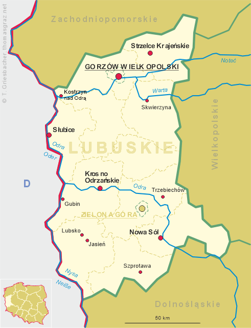
 Szprotawa (German: Sprottau)
is situated at an elevation of 120 m at the confluence of the rivers Szprotawa (Sprotte) and
Bóbr (Bober) in southwest Poland, about 33 km southwest of Nowa Sól and
74 km southeast of Krosno Odrzańskie, the two capitals of the Lebus voivodship.
The municipality of Szprotawa has a population of about 11,800 (2019).
Szprotawa (German: Sprottau)
is situated at an elevation of 120 m at the confluence of the rivers Szprotawa (Sprotte) and
Bóbr (Bober) in southwest Poland, about 33 km southwest of Nowa Sól and
74 km southeast of Krosno Odrzańskie, the two capitals of the Lebus voivodship.
The municipality of Szprotawa has a population of about 11,800 (2019).
In the year 1000 Emperor Otto III met here with Duke Bolesław I Chobry ('the Brave'; later first King of Poland) while he, the emperor, was on a pilgrimage to Gniezno (Gnesen). In 1254 it obtained the privileges as a town, the oldest existing documents of the town date from 1263. In 1304, Szprotawa gained full city rights and privileges, including the internal organization of the city council. In 1331, together with the Duchy of Głogów, Szprotawa, although ruled by the Polish Piast dynasty, became a fief of the Bohemian (Czech) Crown. In 1506 it was incorporated into the Bohemian Kingdom. It was since ruled by the Jagiellonian dynasty until 1526 when it came in passed to the House of Habsburg. Since the Middle Ages, the town's wealth was primarily attributable to trade, mainly in cattle, salt and grain, from Silesia and Greater Poland to German states. From the 14th century also hammer mills were located here. After the First Silesian War in 1742 Szprotawa, under the Germanised name Sprottau, fell to Prussia, like almost all Silesia. After the reorganization of Prussia in 1815, Sprottau became part of the province of Silesia, and from 1816 was the seat of the district of Sprottau, part of the government district of Liegnitz (Legnica). With the Unification of Germany in 1871, Sprottau was incorporated into the German Empire. In the first half of the 20th century, the city had an economic boom in the iron, textile and wax goods industry. During World War II about 90% of the city was destroyed. After the war, the redrawn borders forced upon Germany and Poland by the Soviet Union in the Potsdam Agreement placed the town, once again, inside Poland. The German-speaking population was expelled and was replaced by Poles from the former east Poland (today Belarus).
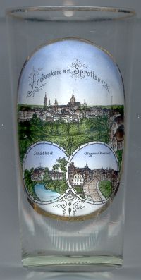
 The
The  old town hall [left, no. 3864: the first and third of the three towers
depicted in the left background] goes back to the 14th century. The town hall has two towers, which is rare in
the country. The eastern tower is crooked and the angle of its inclination is successively increasing. It was originally
built in the years 1536–1587. The west tower was added in the first decade of the 17th century. Both suffered
severely during fires in 1672 and 1702. Shortly after 1720, the eastern tower was rebuilt, and the western one in 1730.
Immediately after the western tower was put into use, its entire structure collapsed and the tower was rebuilt in 1732.
old town hall [left, no. 3864: the first and third of the three towers
depicted in the left background] goes back to the 14th century. The town hall has two towers, which is rare in
the country. The eastern tower is crooked and the angle of its inclination is successively increasing. It was originally
built in the years 1536–1587. The west tower was added in the first decade of the 17th century. Both suffered
severely during fires in 1672 and 1702. Shortly after 1720, the eastern tower was rebuilt, and the western one in 1730.
Immediately after the western tower was put into use, its entire structure collapsed and the tower was rebuilt in 1732.
The Protestant church [left, no. 3864: the middle of the three towers
depicted in the left background] was erected on the foundations of the old castle. Construction work began in 1744.
The rubble of the old castle was used to fill the old moat. Fragments of the medieval castle walls were used to build new
temple walls. The castle bastion was used to arrange a crypt in it, and a sacristy in the upper floor. The northern walls
and the tower were built from scratch. The church was completed in 1747. The church functioned until 1945. After the
displacement of the German population after World War II, it systematically fell into ruin. In the 1960s the roof and
the copper dome of the tower collapsed. Currently, the church is being rebuilt by the Polish Catholic parish.
The Catholic church of the Assumption of the Blessed Virgin Mary [left, no. 3864:
right background] was first mentioned in 1260. The Gothic church, originally a single-nave stone structure without
a tower, was expanded to a three-nave structure in 1416–1424. The interior was is from the Baroque and Rococo periods.
From 1314 until 1811 it was under the patronage of the local monastery of St. Magdalene. Until the beginning
19th century surrounded by a wall and a cemetery. Numerous tombstones and commemorative plaques are embedded in the
outer walls.
The lower left picture on glass no. 1454 [top left] shows the
municipal
The lower right picture shows a view of the
suburb
[https://de.wikipedia.org/wiki/Szprotawa, https://en.wikipedia.org/wiki/Szprotawa;
https://pl.wikipedia.org/wiki/Ratusz_w_Szprotawie;
https://pl.wikipedia.org/wiki/Ko%C5%9Bci%C3%B3%C5%82_ewangelicki_w_Szprotawie;
https://pl.wikipedia.org/wiki/Ko%C5%9Bci%C3%B3%C5%82_Wniebowzi%C4%99cia_Naj%C5%9Bwi%C4%99tszej_Maryi_Panny_w_Szprotawie]
![[scale]](lineal.jpg)