
|
|
| DEUTSCHLAND | GERMANY |
| Bundesland: Freistaat Sachsen | Saxony |
| Landkreis: Zwickau |
map →

 Limbach-Oberfrohna is situated at an elevation of 350 m just 12 km west of Chemnitz in
Germany's state of Saxony. Both villages were founded in the 12th century, together with numerous others, by colonists
from Franconia and from the Rhineland. Limpach was first mentioned in 1248, Cuerchfrone in 1415;
the stream Vrone was mentioned in 1285. In 1682 the first loom for knitting stockings was set up here.
Since then, Limbach became the centre of the knitting in Saxony. Limbach became a market town in 1795
and was chartered as a town in 1883. Oberfrohna obtained the status of a town in 1935. The two towns were
merged into the municipality of Limbach-Oberfrohna in 1950.
Limbach-Oberfrohna is situated at an elevation of 350 m just 12 km west of Chemnitz in
Germany's state of Saxony. Both villages were founded in the 12th century, together with numerous others, by colonists
from Franconia and from the Rhineland. Limpach was first mentioned in 1248, Cuerchfrone in 1415;
the stream Vrone was mentioned in 1285. In 1682 the first loom for knitting stockings was set up here.
Since then, Limbach became the centre of the knitting in Saxony. Limbach became a market town in 1795
and was chartered as a town in 1883. Oberfrohna obtained the status of a town in 1935. The two towns were
merged into the municipality of Limbach-Oberfrohna in 1950.
The picture on glass no. 1457 [left] shows the square
 Ludwigsplatz post office
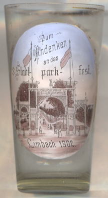
Glass no. 4908 [near left] is a souvenir for the
Stadtparkfest 1902
[https://www.limbach-oberfrohna.de/de/geschichte-zeittafel.html]
![[scale]](lineal.jpg)