
|
|
| DEUTSCHLAND | GERMANY |
| Bundesland: Niedersachsen | Lower Saxony |
| Landkreis: Göttingen |
map →
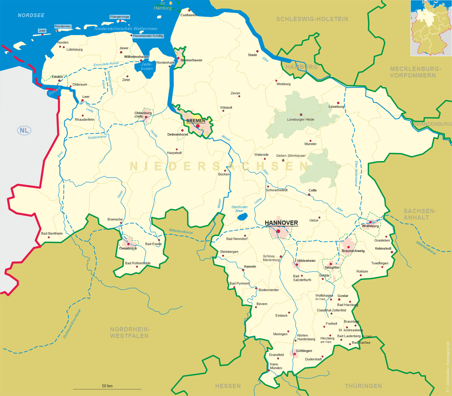
 Dransfeld is situated at an elevation of 407 m in southern Lower Saxony about 15 km northwest of Göttingen.
The place was first mentioned in a document of AD 960 (Threnesfelde). Dransfeld obtained the status of a town in the
14th century. In 1973, the city of Dransfeld was merged with the surrounding municipalities of Bühren, Jühnde, Niemetal and Scheden.
Dransfeld is situated at an elevation of 407 m in southern Lower Saxony about 15 km northwest of Göttingen.
The place was first mentioned in a document of AD 960 (Threnesfelde). Dransfeld obtained the status of a town in the
14th century. In 1973, the city of Dransfeld was merged with the surrounding municipalities of Bühren, Jühnde, Niemetal and Scheden.
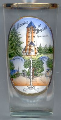
The  old Gaußturm [top picture] was built in 1911 on the Hoher Hagen (508 m) in
memory of the mathematician Karl Friedrich Gauß (1777–1855). Gauß became professor of mathematics and director of the observatory
of the university of Göttingen in 1807. In 1821–1824 he began his mensurations on the Hoher Hagen in order
to prove the validity of Euklidian calculations. The old lookout tower was removed in 1961 to make way for the enlarged basalt quarries.
A new, modern tower, a reinforced concrete construction (51 m high), was built nearby as a replacement in 1964.
old Gaußturm [top picture] was built in 1911 on the Hoher Hagen (508 m) in
memory of the mathematician Karl Friedrich Gauß (1777–1855). Gauß became professor of mathematics and director of the observatory
of the university of Göttingen in 1807. In 1821–1824 he began his mensurations on the Hoher Hagen in order
to prove the validity of Euklidian calculations. The old lookout tower was removed in 1961 to make way for the enlarged basalt quarries.
A new, modern tower, a reinforced concrete construction (51 m high), was built nearby as a replacement in 1964.
The bottom left picture shows the Bahnhofstraße (Station Road) of Dransfeld. The railway line from
Göttingen via Dransfeld to Hannoversch Münden (Hannöversche Südbahn) was
opened in 1856. Passenger traffic was terminated in 1980
The bottom right picture shows the Mündener Tor (Münden Gate) [bottom right],
a crossroads with four oak trees.
![[scale]](lineal.jpg)