
|
|
| ÖSTERREICH | AUSTRIA |
| Bundesland: Niederösterreich | Lower Austria |
| Bezirk: Scheibbs |
map →

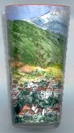 Scheibbs is situated at an elevation of 333 m in the valley of the river Erlauf in Lower Austria.
The earliest mention of Scheibbs is found in a document of 1160. In 1338 the village became the seat
of the administration of the domains of the monastery of Gaming,
which may have been associated with an elevation to a market town. In 1352 Scheibbs was
chartered as a town. During the 16th century, in 1588, Scheibbs became the main market town
of the Eisenwurzen region. This flourishing period lasted until the 1781/1782, when the iron works
of the region lost their monopoles and the monastery of Gaming was dissolved.
The industrialisation of the area began with the opening in 1820 of the 'First Imperial Factory for
Iron, Steel and Rolled Sheet Metals' (Erste k.k. Eisen, Stahl- und Walzblechfabrik).
The Erlau valley railroad was copleted in 1877. Scheibbs was the first town in the entire
Austrian Monarchy to receive electric street lighting in 1886. Scheibbs was granted the status of a town again in 1926.
Scheibbs is situated at an elevation of 333 m in the valley of the river Erlauf in Lower Austria.
The earliest mention of Scheibbs is found in a document of 1160. In 1338 the village became the seat
of the administration of the domains of the monastery of Gaming,
which may have been associated with an elevation to a market town. In 1352 Scheibbs was
chartered as a town. During the 16th century, in 1588, Scheibbs became the main market town
of the Eisenwurzen region. This flourishing period lasted until the 1781/1782, when the iron works
of the region lost their monopoles and the monastery of Gaming was dissolved.
The industrialisation of the area began with the opening in 1820 of the 'First Imperial Factory for
Iron, Steel and Rolled Sheet Metals' (Erste k.k. Eisen, Stahl- und Walzblechfabrik).
The Erlau valley railroad was copleted in 1877. Scheibbs was the first town in the entire
Austrian Monarchy to receive electric street lighting in 1886. Scheibbs was granted the status of a town again in 1926.
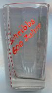
The labelling "Scheibbs 600 Jahre" on the back side of glass no. 1532 most likely refers to the 600th anniversary of
the (presumed) elevation to a market town in 1338 because the glass seems to be too old for the 1952 anniversary of the
town charter of 1352.
![[scale]](lineal.jpg)