
|
|
| DEUTSCHLAND | GERMANY |
| Bundesland: Freistaat Sachsen | Saxony |
| Landkreis: Erzgebirgskreis |
map →

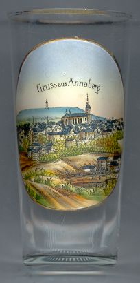 Annaberg is situated at an elevation of 673 m at the foot of the Hoher Pöhlberg (823 m) in the Erzgebirge
region of soutwestern Saxony. The town was founded in 1496 as Neustadt am Schreckenberg five years after silver had
been found in the Schreckenberg mountain. Already in 1497 it was chartered as a town. Two years after the church of
St. Anne (see below) was begun, the town became known as Sankt Annaberg. At that time it was the
second-largest town in Saxony. The mining of silver reached its peak in 1537. The tradition of lace manufacture is
documented since 1561. The first factory for ornamental trimmings opened in 1832. This industry became so important that
an own technical school for this brach of industry was founded here in 1909.
The railroad from Annaberg to Chemnitz was opened in 1860, the railroad to Weipert (now Vejprty, CZ)
in Bohemia followed in 1872. After World War II, Annaberg and the town of Buchholz were merged in 1945; the new
municipality took the name Annaberg-Buchholz.
Annaberg is situated at an elevation of 673 m at the foot of the Hoher Pöhlberg (823 m) in the Erzgebirge
region of soutwestern Saxony. The town was founded in 1496 as Neustadt am Schreckenberg five years after silver had
been found in the Schreckenberg mountain. Already in 1497 it was chartered as a town. Two years after the church of
St. Anne (see below) was begun, the town became known as Sankt Annaberg. At that time it was the
second-largest town in Saxony. The mining of silver reached its peak in 1537. The tradition of lace manufacture is
documented since 1561. The first factory for ornamental trimmings opened in 1832. This industry became so important that
an own technical school for this brach of industry was founded here in 1909.
The railroad from Annaberg to Chemnitz was opened in 1860, the railroad to Weipert (now Vejprty, CZ)
in Bohemia followed in 1872. After World War II, Annaberg and the town of Buchholz were merged in 1945; the new
municipality took the name Annaberg-Buchholz.
The  Sankt Annenkirche (church of St. Anne) [centre]
was built in 1499–1525 and is the largest and one of the most important examples of the late Gothic Upper Saxon hall churches.
The massive tower was completed in1532. In 1539 the church became Protestant. Art historical treasures are the intricate late Gothic ribbed vaulting and numerous carved stone reliefs.
The "Bergaltar" ("mountain altar") was created in 1521 by Hans Witten and an unknown sculptor. It is one of the world's very first pieces of art
depicting labourers. The baptismal font and the "Beautiful Gate", originally created for the monasteries of Chemnitz and Annaberg,
also were created by Hans Witten. Two of the large bells in the tower, cast in 1814, were confiscated in 1942 but fortunately were not melted down. They
were found again in Hamburg and returned to the church in 1948.
The large organ was built in 1884 by the Walcker company and was reconstructed in 1992–1995.
Sankt Annenkirche (church of St. Anne) [centre]
was built in 1499–1525 and is the largest and one of the most important examples of the late Gothic Upper Saxon hall churches.
The massive tower was completed in1532. In 1539 the church became Protestant. Art historical treasures are the intricate late Gothic ribbed vaulting and numerous carved stone reliefs.
The "Bergaltar" ("mountain altar") was created in 1521 by Hans Witten and an unknown sculptor. It is one of the world's very first pieces of art
depicting labourers. The baptismal font and the "Beautiful Gate", originally created for the monasteries of Chemnitz and Annaberg,
also were created by Hans Witten. Two of the large bells in the tower, cast in 1814, were confiscated in 1942 but fortunately were not melted down. They
were found again in Hamburg and returned to the church in 1948.
The large organ was built in 1884 by the Walcker company and was reconstructed in 1992–1995.
Between 1523 and 1559 Annaberg was home of the famous mathematician Adam Ries (1492–1559).
The mountain depicted in the background is the
Pöhlberg lookout tower
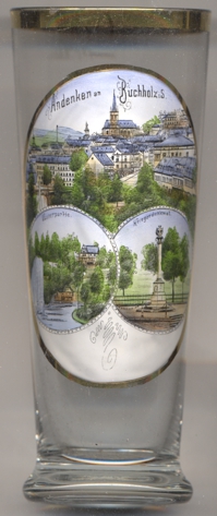 Buchholz is situated at an altitude of 565 m about 3 km southwest of Annaberg on a steep slope of the valley of the river Sehma.
The river marks the boundary between Buchholz to the west and Annaberg to the east of the river.
Buchholz is situated at an altitude of 565 m about 3 km southwest of Annaberg on a steep slope of the valley of the river Sehma.
The river marks the boundary between Buchholz to the west and Annaberg to the east of the river.
Since the Partition of Leipzig (1485), the river Sehma marked the boundary between the Ernestine and the Albertine parts of Saxony. A mining settlement was founded below Annaberg in 1495 and at first was named St. Katharinenberg im Buchholz, which became the origin of the later name Buchholz. First privileges were granted to the settlement in 1501, although at the time it counted 16 homeowners. In 1507 the village received an own mining order. The privileges as a market town were granted in 1520. It was only after the Capitulation of Wittenberg of 1547 that Buchholz joined the Albertine part of Saxony. At the time of the Reformation, the river marked the religious boundary between the Protestant and Catholic areas. In 1620 and in the years that followed, many Bohemian exiles came, especially from Gottesgab (today Boží Dar) and St. Joachimsthal (today Jáchymov). The town, which had no city walls, was severly damaged during the Thirty Years' War (1618–1648). In 1868 a manufacturing process for beaded fabric was invented herey, which led to an economic boom as Buchholz held a monopoly for it. On 1 July 1945, Annaberg and Buchholz were merged into the new municipality of Annaberg-Buccholz.
The Protestant church Sankt Katharinen [left, no. 4129: top picture, background centre]
was built in 1506–1523 as a three-naved church. At first it only had a wooden ceiling. It took until the end of the 19th century that sufficient
funds were available for a representative church building. The church was vaulted and was provided with galleries according to the design of the
architect Gotthild Ludwig Möckel. The tower was also heightened. In February 1945, the church was destroyed by an air raid, the vault and pillars
collapsed and only the enclosing walls remained. The recontruction, without vaulting, took place until 1981. The magnificent winged altar from around
1520 survived as it had been moved to the sacristy during the war.
The bottom left picture shows a view labeled
Wasserpartie soldiers' monument
[https://de.wikipedia.org/wiki/Annaberg-Buchholz;
https://de.wikipedia.org/wiki/St._Annenkirche_(Annaberg-Buchholz);
https://de.wikipedia.org/wiki/P%C3%B6hlberg;
https://de.wikipedia.org/wiki/Buchholz_(Annaberg-Buchholz);
https://de.wikipedia.org/wiki/St._Katharinen_(Buchholz)]
![[scale]](lineal.jpg)