
|
|
| DEUTSCHLAND | GERMANY |
| Bundesland: Freistaat Sachsen | Saxony |
| Landkreis: Erzgebirgskreis |
map →

Grünhain-Beierfeld is situated at an elevation of 505 m in the Erzgebirge (Ore Mountains) region of Saxony. Since 1 January 2005 Grünhain is part of the municipality Grünhain-Beierfeld.
Grünhain is situated at an elevation of 626 m in the Erzgebirge (Ore Mountains) region of Saxony. Since 2005 Grünhain is part of the municipality Beierfeld-Grünhain.
The area was first mentioned as a settlement area around 1150. The earliest document mentioning Gruninhain dates from 1231/33. The village itself was first mentioned as 'oppidum' (a little town) in 1267 and in 1285 received further privileges. For three centuries, until its closure in 1536, the Cistercian monastery, founded around 1230, was one of the richest in the area. Since the early 19th century Grünhain became known as a spa place. In 1900 Grünhain was connected to the railroad system (raway line from Zwönitz to Scheibenberg; closed in 1947). Due to a financial crisis of the town, Grünhain in 2005 was incorporated into the neighbouring municipality of Beierfeld, which thus assumed the status of a town and changed its name to Grünhain-Beierfeld.
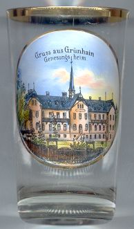
The  Genesungsheim (convalescent home) [left]
was founded in 1897 by the Medical Insurance Company of Chemnitz.
Genesungsheim (convalescent home) [left]
was founded in 1897 by the Medical Insurance Company of Chemnitz.
The composer and cantor of St. Thomas in Leipzig, Johann Hermann SCHEIN (1586–1630),
was born in Grünhain.
[https://de.wikipedia.org/wiki/Grünhain-Beierfeld, https://de.wikipedia.org/wiki/Grünhain-Beierfeld, https://de.wikipedia.org/wiki/Kloster_Grünhain]
![[scale]](lineal.jpg)