
|
|
| DEUTSCHLAND | GERMANY |
| Bundesland: Baden-Württemberg | |
| Regierungsbezirk: Stuttgart | |
| Landkreis: Ostalbkreis |
map →

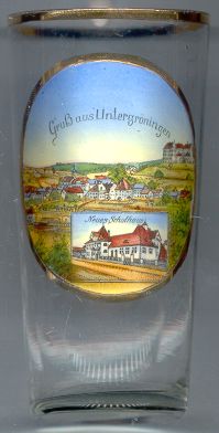 Untergröningen is situated at an elevation of 372 m in the Kocher valley of eastern Baden-Württemberg.
The oldest traces of human settlements date from the Stone Ages. In the 3rd century the Kocher valley
was then settled by the Alemanni. The oldest mention of Gröningen is found in a document of 1102.
Until the 16th century Untergröningen was known as Gröningen-Stadt (town) while Obergröningen
was known as Gröningen-Dorf (village). The name Untergröningen was first documented in 1537.
In 1806/1827 Untergrönigen became part of Württemberg.
Untergröningen was an independent municipality until 1971
when it became part of the municipality of Abtsgmünd.
Untergröningen is situated at an elevation of 372 m in the Kocher valley of eastern Baden-Württemberg.
The oldest traces of human settlements date from the Stone Ages. In the 3rd century the Kocher valley
was then settled by the Alemanni. The oldest mention of Gröningen is found in a document of 1102.
Until the 16th century Untergröningen was known as Gröningen-Stadt (town) while Obergröningen
was known as Gröningen-Dorf (village). The name Untergröningen was first documented in 1537.
In 1806/1827 Untergrönigen became part of Württemberg.
Untergröningen was an independent municipality until 1971
when it became part of the municipality of Abtsgmünd.
 Gröningen castle [top right] goes back to a stronghold of the late 11th century
The present castle was built in 1564. Parts of the castle were altered in 1770–1780.
Gröningen castle [top right] goes back to a stronghold of the late 11th century
The present castle was built in 1564. Parts of the castle were altered in 1770–1780.
The building depicted in the bottom picture on glass no. 1710 is labeled
Neues
![[scale]](lineal.jpg)