
|
|
| DEUTSCHLAND | GERMANY |
| Bundesland: Freistaat Sachsen | Saxony |
| Landkreis: Mittelsachsen |
map →

 Mittweida is situated at an elevation of 214–342 m in the romantic valley of the river Zschopau.
The origins of Mittweida go back to the mid-12th century. The name Mittweida was first mentioned in a document of 1209. Already in 1289 it is mentioned as 'oppidum', a town. At least since 1375 Mittweida had its own town council and a mayor. The right for civil and criminal jurisdiction was acquired in 1398 and 1423. Throughout its history, the town was devastated by fires several times, such as in 1306 during the siege by Duke Albrecht I of Austria, in 1450 during the Saxon Fratricidal War between Friedrich II, Elector of Saxony, and his brother, Landgrave Wilhelm III of Thuringia. Further fires occurred in 1498, 1551, 1624, 1672, 1693, 1868, 1914 and 1963. The origins of textile industry in Mittweida go back to the 15th century. The modern development of the industry began in 1816 with the foundation of a mechanical spinning mill. The railroad from Chemnitz via Mittweida to Riesa was opened in 1852, the Zschopau valley railroad was built in 1905–1908. Since the mid-20th century tourism became another important factor for the economy of Midweida. The Zschopau river dam at Kriebstein, built in 1927–1930, created another tourist attraction in the area. The town was fortunate as it did not suffer severe damages during both world wars.
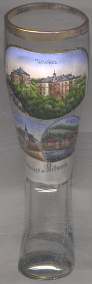
The  Technikum Mittweida [left, no. 3539] was founded in 1867.
From 1900 onwards, it became one of Germany's largest and most important private technical schools for mechanical and
electrical engineers. After the takeover by the National Socialists, it lost its status as a private school, and in 1935
became the Ingenieurschule Mittweida ('Engineering School Mittweida'). In the 1969, due to the success of the
electrotechnical training program, the school became the Ingenieurschule Mittweida. In 1980, it received the right
to award the academic degree of 'doctor engineer'. In 1992, after the reunification, the college received a new start as a
university of applied sciences. In 1998, to reflect its modern role, the university was renamed as the Hochschule
Mittweida ('University of Applied Sciences Mittweida'). It is today the second-largest public university of applied
sciences in Saxony.
[https://de.wikipedia.org/wiki/Hochschule_Mittweida, https://en.wikipedia.org/wiki/Hochschule_Mittweida]
Technikum Mittweida [left, no. 3539] was founded in 1867.
From 1900 onwards, it became one of Germany's largest and most important private technical schools for mechanical and
electrical engineers. After the takeover by the National Socialists, it lost its status as a private school, and in 1935
became the Ingenieurschule Mittweida ('Engineering School Mittweida'). In the 1969, due to the success of the
electrotechnical training program, the school became the Ingenieurschule Mittweida. In 1980, it received the right
to award the academic degree of 'doctor engineer'. In 1992, after the reunification, the college received a new start as a
university of applied sciences. In 1998, to reflect its modern role, the university was renamed as the Hochschule
Mittweida ('University of Applied Sciences Mittweida'). It is today the second-largest public university of applied
sciences in Saxony.
[https://de.wikipedia.org/wiki/Hochschule_Mittweida, https://en.wikipedia.org/wiki/Hochschule_Mittweida]
The bottom left picture on glass no. 3539 [left] shows a view of the
market square
The bottom right picture on glass no. 3539 [left] shows a view of the
Lauenhain mill
Lauenhain, today part of Mittweida, was already mentioned as Lewynhayn in a document of 1293.
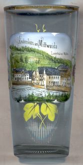
The Lauenhainer Mühle (Lauenhain mill), depicted on glass
no. 1791 [near left], was built in 1904.
Apart from serving as a mill it also housed a cardboard manufactory and a popular restaurant.
When the Zschopau river dam at Kriebstein was built the mill was dismantled before the site was flooded in 1929 by the rising waters of the
reservoir.
![[scale]](lineal.jpg)