
|
|
| ČESKÁ REPUBLIKA | CZECH REPUBLIC |
| Liberecký kraj | Liberec region |
| Okres: Semily |
map →
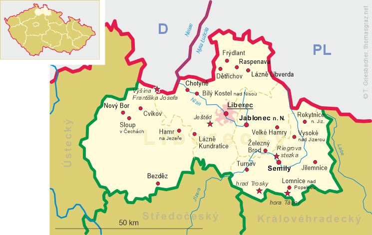
 Vysoké nad Jizerou (German: Hochstadt an der Iser) is situated at an elevation of 667 m on an elevated area
above the Jizera (Iser) river in the Vysocká hornatina (Hochstädter Bergland) mountains of northern Bohemia,
in the district Semily.
Vysoké nad Jizerou (German: Hochstadt an der Iser) is situated at an elevation of 667 m on an elevated area
above the Jizera (Iser) river in the Vysocká hornatina (Hochstädter Bergland) mountains of northern Bohemia,
in the district Semily.
The first written mention of the town is found in a document of 1354. It is likely that it had been founded not long before by the Valdštejn (Wallenstein) family. The reason for the foundation of the settlement was mining of ore and gold, forestry, and the early development of glass making industry.
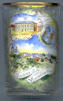
The  coat of arms of Vysoké nad Jizerou [top right] dates from the 16th century.
The church of St. Catherine (Kostel sv. Kateřiny Alexandrijské) [bottom picture, left]
was built between 1725 and 1743 in place of an older church of the mid-14th century. A treasure of the church is a wooden statue of the Madonna dating from the 14th century.
The top left picture on glass no. 2033 is labeled Škola
The glass also bears the labeling '1392' between the two top pictures. This most likely refers to the earliest mention of Vysoké nad Jizerou that was
known at the time of the making of the glass (around 1900).
![[scale]](lineal.jpg)