
|
|
| DEUTSCHLAND | GERMANY |
| Bundesland: Baden-Württemberg | |
| Regierungsbezirk: Stuttgart | |
| Landkreis: Schwäbisch Hall |
map →

 Tüngental is situated at an elevation of 381 m about 6 km east of the district town, Schwäbisch Hall, in northeastern Baden-Württemberg.
In 1972 Tüngental was incorporated into the municipality of Schwäbisch Hall.
Tüngental is situated at an elevation of 381 m about 6 km east of the district town, Schwäbisch Hall, in northeastern Baden-Württemberg.
In 1972 Tüngental was incorporated into the municipality of Schwäbisch Hall.
The place was presumably founded in Karolinigian times. The earliest document mentioning Tüngental dates from AD 1078 and refers to the foundation of the monastery of Comburg. Parts of the village were in possession of the monastery of Comburg (see Schwäbisch Hall), other parts of the domain and the sovereignty was in the hands of Schwäbisch Hall. In 1802 the Tüngental became part of Württemberg.
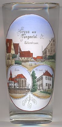
the top picture on glass no. 2158 shows a view of the street,
 Kellerstraße.
The bottom left picture on glass no. 2158 shows the Protestant parish church of Our Lady.
The (Catholic) parish was presumably founded around 1050. The church was destroyed in 1945. After the war, the church was rebuilt in 1949/1950 on the foundations of the
earlier churches from around 1050. Parts of older foundations were even dated to the Karolingian times.
The bottom right picture on glass no. 2158 shows the parsonage.
![[scale]](lineal.jpg)