
|
|
| DEUTSCHLAND | GERMANY |
| Bundesland: Freistaat Thüringen | Thuringia |
| Landkreis: Saale-Holzland-Kreis |
map →
 Bad Klosterlausnitz is situated at an elevation of 323 m in the east of the
Saale-Holzland district of Thuringia, about 5 km southwest of the district town,
Eisenberg/Thüringen. Bad Klosterlausnitz has a population
of about 3,700 and also fulfils the administrative duties for the neighbouring
municipalities of Albersdorf, Bobeck, Scheiditz, Schlöben, Schöngleina, Serba,
Tautenhain, Waldeck and Weißenborn.
Bad Klosterlausnitz is situated at an elevation of 323 m in the east of the
Saale-Holzland district of Thuringia, about 5 km southwest of the district town,
Eisenberg/Thüringen. Bad Klosterlausnitz has a population
of about 3,700 and also fulfils the administrative duties for the neighbouring
municipalities of Albersdorf, Bobeck, Scheiditz, Schlöben, Schöngleina, Serba,
Tautenhain, Waldeck and Weißenborn.
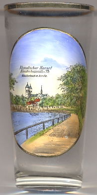
The oldest written mention of Klosterlausnitz, a document issued by Pope Innocent II,
dates from 1137. The monastery of the Augustine Canonesses was founded in c.1150–1181/85,
but was dissolved in 1526.
The  monastery church [left, no. 2768: background]
was rebuilt in 1855–1866.
After the comletion in 1876 of the railway line from Weimar to Gera
tourism became an important economic factor for Klosterlausnitz which soon became known as a climatic spa place.
The first mud bath spa was founded in 1929. In 1932 the predicate 'Bad' was added to the town name as a
recognition of its role as a spa town.
monastery church [left, no. 2768: background]
was rebuilt in 1855–1866.
After the comletion in 1876 of the railway line from Weimar to Gera
tourism became an important economic factor for Klosterlausnitz which soon became known as a climatic spa place.
The first mud bath spa was founded in 1929. In 1932 the predicate 'Bad' was added to the town name as a
recognition of its role as a spa town.
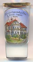
The picture on glass no. 2191 shows the
Ernst-Agnes-Heim
[http://www.bad-klosterlausnitz.info/cms/2/?i=1:.5.4.21....de]
![[scale]](lineal.jpg)