
|
|
| DEUTSCHLAND | GERMANY |
| Bundesland: Freistaat Bayern | Bavaria |
| Regierungsbezirk: Mittelfranken | |
| Landkreis: Ansbach |
map →

 Dinkelsbühl is situated at an elevation of 444 m on the river Wörnitz in the Ansbach district of Middle Frankonia.
Dinkelsbühl has a population of about 11,700 (2005).
Dinkelsbühl is situated at an elevation of 444 m on the river Wörnitz in the Ansbach district of Middle Frankonia.
Dinkelsbühl has a population of about 11,700 (2005).
Fortified around 1130, the burgus Tinkelspuhel was first mentioned in a deed of donation of 1188. In 1274 Dinkelsbühl obtained the status of a free imperial city and was granted inportant privileges. During the Thirty Years' War (1618–1648), the town was captured and occupied several times by the various opposing troops. However, when the town was conquered by the Swedes in 1632, it was spared looting and destruction. These events are reenacted today each year in a popular festival, the "Kinderzeche". The independence of the city ended in 1802, when the city became part of Bavaria. In 1826, King Ludwig I decreed that the fortifications of the city should not be pulled down. Luckily, Dinkelsbühl was spared damage during both World Wars and thus large parts of the historic appearance are preserved until today.
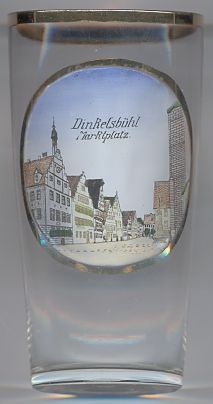
The picture on glass no. 2321 [left] is labeled  Marktplatz
![[scale]](lineal.jpg)