
|
|
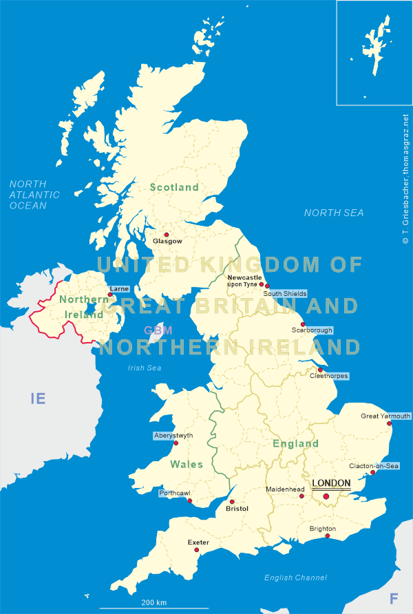
| UNITED KINGDOM OF GREAT BRITAIN AND NORTHERN IRELAND |
| England |
| Region: North East England |
| Metropolitan Borough: Newcastle upon Tyne – Ceremonial County: Tyne and Wear |
map →
Newcastle upon Tyne is a city and metropolitan borough of Tyne and Wear, England. Situated on the north bank of the River Tyne, the city owes its name to the Norman castle built in 1080, by Robert II, Duke of Normandy, the eldest son of William the Conqueror. The area around Newcastle was historically a Roman settlement. The auxiliary castra and small Roman settlement on Hadrian's Wall in the Roman province of Britannia Inferior (Upper Britain — the Romans judged distances by proximity to Rome, therefore north England is inferior as it is farther away) was called Pons Aelius. The medieval Latin name was Novum Castrum super Tynum, of which the modern name is a literal translation. The city grew as an important centre for the wool trade and it later became a major coal mining area. The port developed in the 16th century and, along with the shipyards lower down the river, was amongst the world's largest shipbuilding and ship-repairing centres. These basic industries have now gone and the city is largely an administrative and cultural centre with two universities — Newcastle and Northumbria. With a population of about 190,000 (2001), the city is the twentieth most populous in England; the larger Tyneside conurbation, of which Newcastle forms part, is the sixth most populous conurbation (ca. 880,000 as of 2001) in the United Kingdom.
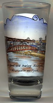
The  High Level Bridge [top background] was designed by Robert Stephenson and was built between 1847 and 1849.
It is the first major example of a wrought iron tied arch or bow-string girder bridge. It is a fine and long standing engineering solution to a difficult problem;
the spanning of 1337 feet (408 m) of river valley, including 512 feet (156 m) across water. The High Level Bridge has six river spans of 125 feet (38 m) length,
sitting on masonry piers, 46 by 16 feet (14 by 5 m) in section and up to 131 feet (40 m) height. There are also four land spans on each side, of 36 feet 3 inches (11 m).
The single carriageway road and pedestrian walkways occupy the lower deck of the spans, 85 feet (26 m) above the high water mark, and the railway the upper deck
112 feet (34 m) above the high water mark. The total weight of the structure is 5,000 tons.
High Level Bridge [top background] was designed by Robert Stephenson and was built between 1847 and 1849.
It is the first major example of a wrought iron tied arch or bow-string girder bridge. It is a fine and long standing engineering solution to a difficult problem;
the spanning of 1337 feet (408 m) of river valley, including 512 feet (156 m) across water. The High Level Bridge has six river spans of 125 feet (38 m) length,
sitting on masonry piers, 46 by 16 feet (14 by 5 m) in section and up to 131 feet (40 m) height. There are also four land spans on each side, of 36 feet 3 inches (11 m).
The single carriageway road and pedestrian walkways occupy the lower deck of the spans, 85 feet (26 m) above the high water mark, and the railway the upper deck
112 feet (34 m) above the high water mark. The total weight of the structure is 5,000 tons.
The Swing Bridge [centre foreground] over the River Tyne is located between the Tyne Bridge and the High Level Bridge.
The hydraulic power to move the bridge is derived from electrically driven pumps. This feeds a hydraulic accumulator sunk into a shaft on the side of the river,
the water is then released under pressure which runs the machinery to turn the bridge. The mechanism used for this is still the same machinery originally installed.
The bridge has an 85.7 metre cantilevered span with a central axis of rotation able to move through 360° to allow vessels to pass on either side of it.
The hydraulic Swing Bridge was designed and paid for by William George Armstrong, 1st Baron Armstrong, with work beginning in 1873.
It was first used for road traffic on 15 June 1876 and opened for river traffic on 17 July 1876.
The earliest bridge across the Tyne, Pons Aelius, was built by the Romans near the location of the present Tyne Bridge. Built around 122, it fell into disrepair,
and a stone bridge was built in 1270. This was in turn destroyed by the great flood of 1771. In 1781, a new stone bridge across the Tyne was completed.
Increased shipping activity led to the stone bridge being removed in 1866 to make way for construction of the present Swing Bridge. The idea for a bridge at the
location of the present Tyne Bridge dates back to 1864, due to concern about the cost of tolls on the High Level Bridge — although the first
serious discussions took place only in 1883. Committees met over the next three decades, but it wasn't until the early 1920s that proposals were commenced in earnest,
boosted by the chance to secure central government funding. On 29 April 1924, Newcastle and Gateshead approved the plans, and the Newcastle upon Tyne and Gateshead
(Corporations) Bridge Act was passed on 7 August that year, with an estimated cost of £1m including land acquisitions. The final cost on completion was £1.2m.
[http://en.wikipedia.org/wiki/Newcastle_upon_Tyne;
http://en.wikipedia.org/wiki/Pons_Aelius;
http://en.wikipedia.org/wiki/Swing_Bridge,_River_Tyne;
http://en.wikipedia.org/wiki/High_Level_Bridge;
http://en.wikipedia.org/wiki/Tyne_Bridge]
![[scale]](lineal.jpg)