
|
|
| DEUTSCHLAND | GERMANY |
| Bundesland: Baden-Württemberg | |
| Regierungsbezirk: Stuttgart | |
| Landkreis: Böblingen |
map →

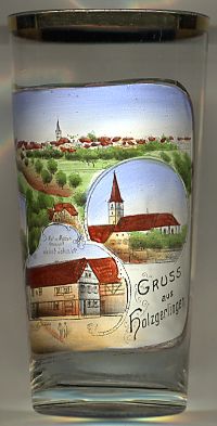 Holzgerlingen is situated at an elevation of 476 m in the Schönbuchlichtung area, about 6 km south of the district town Böblingen.
The municipality has a population of about 12,500 (2007).
Holzgerlingen is situated at an elevation of 476 m in the Schönbuchlichtung area, about 6 km south of the district town Böblingen.
The municipality has a population of about 12,500 (2007).
Archeological finds demonstrate human settlements dating back to the Neolithic period. Celtic settlements existed between about 550 and 50 BC. The Romans, who came into the area around AD 100 were replaced by the Alemanni around AD 300. The earliest written document mentioning Holzgerlinga is a deed of donation of German King (later Emperor) Heinrich II to the newly founded bishopric of Bamberg, dating from 1007. Between about 1100 and 1400 Holzgerlingen was in possession of the palsgraves of Tübingen. Between 1344 and 1354 the village was sold to the counts of Württemberg. The Reformation was introduced in 1534; since then, the majority of the citizens of Holzgerlingen is Protestant. On 1 April 1993 Holzgerlingen obtained the status of a town.
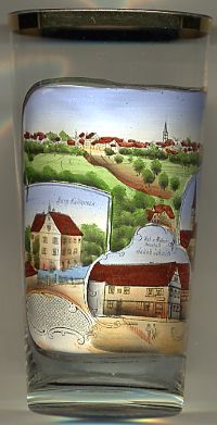
The Protestant  parish church Sankt Mauritius [top right inset] was begun in 1473.
The tower dates back to the 11th century. The church is under monumental protection.
parish church Sankt Mauritius [top right inset] was begun in 1473.
The tower dates back to the 11th century. The church is under monumental protection.
Schloss Kalteneck [top left inset] was built after 1570. The picture shows its
appearance before the renovation of 1956.
The bottom centre inset shows building labeled
Hut-
![[scale]](lineal.jpg)