
|
|
| PORTUGAL | |
| distrito de Porto |
map →
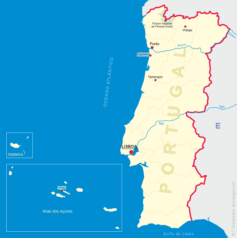
Porto, Portugal's second, is located in the estuary of the Douro river in northern Portugal. The largest city in the region, Porto is considered the economic and cultural heart of the entire region. The city, which had an estimated population of about 220,000 (2008), lies at the centre of the political Greater Metropolitan Area of Porto, with a population of slightly more than 1.7 million, and is the main agglomeration of northern Portugal.
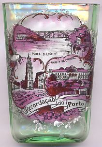 The top picture on glass no. 2515 shows a view of
 Ponte
Ponte
The Torre dos Clérigos [bottom left] is the bell tower of the Clérigos Church.
The church was built for the Brotherhood of the Clérigos (Clergy) by Nicolau Nasoni, an Italian architect and painter who left an extense work in the north of
Portugal during the 18th century. Construction of the church began in 1732 and was finished around 1750, while the monumental divided stairway in front of the
church was completed in the 1750s. The Clérigos Church was one of the first baroque churches in Portugal to adopt a typical baroque elliptic floorplan.
The monumental tower of the church, located at the back of the building, was only built between 1754 and 1763. The baroque decoration here also shows influence
from the Roman Baroque, while the whole design was inspired by Tuscan campaniles. The tower is 75.6 metres high, dominating the city. There are 225 steps to be
climbed to reach the top of its six floors. This great structure has become the symbol of the city.
The Palácio de Cristal [bottom right] was built in 1861–1865 by the English architect Thomas Dillen Jones following the
example of Crystal Palace in London. The edifice had a length of 150 netres, a width of 72 metres and was divided into three naves.
The Palácio de Cristal was designed to accommodate the great International Exposition of Porto of 1865.
In 1933, the building and its gardens were purchased by the Municipality of Porto.
Over its 86 years of existence, the Cristal Palace hosted many more exhibitions, including the Colonial Exhibition of 1934.
The palace was destroyed in 1951. In its place the Pavilhão dos Desportos (Sports Pavillon) was opened in 1954; this arena was renamed Pavilhão Rosa Mota in 1991.
Historic references to the city go back to the 4th century and to Roman times — when it was named Portus Cale —, although
Celtic and Proto-Celtic remnants of ancient Citadels were found in the heart of where Porto now lies. In the Roman period the city developed its importance
as a commercial port, primarily in the trade between Olissipona (Lisbon) and Bracara Augusta (nowadays Braga), but would fall under the Moorish Muslim invasion
of the Iberian Peninsula in 711. In 868, after the reconquest of the region north of the Douro river, the Condado de Portucale, the first county founded in Portugal which derived its name from this county.
In the 14th and the 15th centuries, the shipyards of Porto contributed to the development of the Portuguese fleet. Wine, produced in the Douro valley,
was already in the 13th century transported to Porto in barcos rabelos (flat sailing vessels). In 1703 the Methuen Treaty established the trade relations
between Portugal and England. In 1717, a first English trading post was established in Porto.
The invasion of the Napoleonic troops in Portugal under Marshal Nicolas Jean-de-Dieu Soult is still vividly remembered in Porto. On 29 March 1809, as the population fled from
the advancing troops and tried to cross the river Douro over the Ponte das Barcas (a pontoon bridge), the bridge collapsed under the weight.
The French army was rooted out of Porto by Arthur Wellesley, 1st Duke of Wellington. In August 1820, Porto rebelled against the English presence, resulting
in a civil war in Portugal. In 1822, a liberal constitution was accepted, partly through the efforts of the liberal assembly of Porto (Junta do Porto).
When Miguel of Portugal took the Portuguese throne in 1828, he rejected this constitution and reigned as an absolutist monarch. Porto rebelled again and had
to undergo a siege of eighteen months between 1832 and 1833 by the absolutist army. Porto is also called "Cidade Invicta" (English: Unvanquished City) after
resisting the Miguelist siege. After the abdication of king Miguel the liberal constitution was re-established. Unrest by republicans led to a revolt in Porto
on 31 January 1891. This would result ultimately in the creation of the Portuguese Republic in 1910.
The historic centre of Porto was declared a World Heritage Site by UNESCO in 1996 (see also list of other UNESCO heritage sites).
[Texts adapted from http://en.wikipedia.org/wiki/Porto, http://en.wikipedia.org/wiki/Dom_Luís_Bridge,_Porto, http://en.wikipedia.org/wiki/Clérigos_Church, http://pt.wikipedia.org/wiki/Pal%C3%A1cio_de_Cristal_(Porto)]
![[scale]](lineal.jpg)