
|
|
| FRANCE | FRANCE |
| région: Grand Est | |
| département: 57, Moselle |
map →
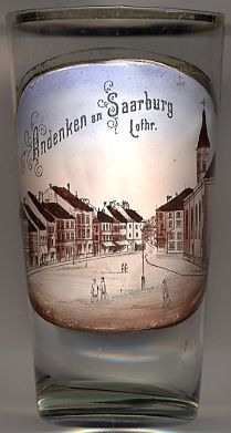 Sarrebourg is situated at an elevation of 290 m at the upper river Sarre (German: Saar) in the département Moselle.
Sarrebourg is the administrative seat of the souspréfecture Sarrebourg. The municipality is part of the collective municipality
Sarrebourg (Communauté de Communes de l'agglomération sarrebourgeoise) which consists of the municipalities of
Sarrebourg, Réding, Buhl-Lorraine, Imling, Hommarting, Sarraltroff, Haut-Clocher and Bébing.
Sarrebourg is situated at an elevation of 290 m at the upper river Sarre (German: Saar) in the département Moselle.
Sarrebourg is the administrative seat of the souspréfecture Sarrebourg. The municipality is part of the collective municipality
Sarrebourg (Communauté de Communes de l'agglomération sarrebourgeoise) which consists of the municipalities of
Sarrebourg, Réding, Buhl-Lorraine, Imling, Hommarting, Sarraltroff, Haut-Clocher and Bébing.
About 2000 years ago the Romans founded a coaching station named Pons Saravi at the site where the Roman trading route from Reims to Strasbourg crossed the river Sarre. The little village soon became an important trading place. The remains of a Roman villa, the Villa Saint-Ulrich, which consisted of 33 separate buildings, still are witness of this important place. The mid-3rd century marked the beginning of the period of Germanic invasions. After the Limes had been abandoned in 259/260 and the Roman border at the Rhine had been abandoned around 455, the area became settled by Frankish people. During the period of the Merovingian dynasty the place was still an important trading centre but seemed to have lost its importance during the Karolingian times. Sarrebourg was protected by the bishops of Metz until King Heinrich I (Henry the Fowler) incorporated the duchy of Lorraine into his Eastfrankish kingdom in 925/928. Sarrebourg then became a fief of the bishops of Metz. However, the relations to Metz deteriorated during the course of the ensuing centuries and Sarrebourg finally, in 1464, voluntarily joined the duchy of Lorraine. The Peace of Vincennes (1661), a contract between the kingdom of France and the duchy of Lorraine, ended a period of conflict between the two countries. France backed out of Lorraine, but several important towns, including Sarrebourg, remained with France in order to provide two corridors from Toul and Verdun to Alsace; the territory of Lorraine consequently was divided into three separate areas. After the French-German War of 1870/1871 Sarrebourg (in German: Saarburg) became part of the newly-founded German Empire and remained with Germany until 1918/1919. Only during World War II Sarrebourg was again occupied by German troops.
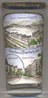
The top picture on glass no. 2524 [near left] shows a view of the
 barracks new barracks
![[scale]](lineal.jpg)