
|
|
| DEUTSCHLAND | GERMANY |
| Bundesland: Baden-Württemberg | |
| Regierungsbezirk: Stuttgart | |
| Landkreis: Göppingen |
map →

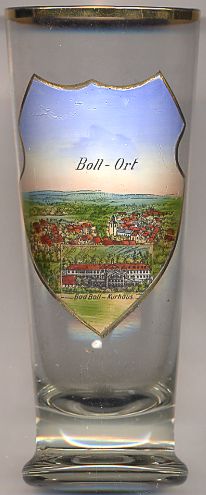 Bad Boll is situated at an elevation of 427 m at the northern edge of the Swabian Alb, about 10 km south of the district town
Göppingen. The municipality of Bad Boll has a population of about 5,200 (2008). Until 31 May 2007 the name of the
municipality was Boll; on 1 June of that year the predicate Bad (spa) was added to the name. The municipality comprises the
localities Boll (with Bad Boll) and Eckwälden, which was incorporated into the mucipality in 1933.
Bad Boll is situated at an elevation of 427 m at the northern edge of the Swabian Alb, about 10 km south of the district town
Göppingen. The municipality of Bad Boll has a population of about 5,200 (2008). Until 31 May 2007 the name of the
municipality was Boll; on 1 June of that year the predicate Bad (spa) was added to the name. The municipality comprises the
localities Boll (with Bad Boll) and Eckwälden, which was incorporated into the mucipality in 1933.
The earliest written document mentioning Boll dates from 1155 and includes a reference to the collegiate church. The suplhur and thermal springs of Boll were discovered in 1595. The Protestant Academy Bad Boll, the first convention facility maintained by a church in Germany, was founded in 1945.
The  collegiate church of Sankt Cyriakus [background centre]
goes back to a church that was founded presumably around AD 800. That church was replaced by the collegiate church in the early 12th century.
The crypt of the church was already part of the original church of the 9th century.
collegiate church of Sankt Cyriakus [background centre]
goes back to a church that was founded presumably around AD 800. That church was replaced by the collegiate church in the early 12th century.
The crypt of the church was already part of the original church of the 9th century.
The Kurhaus (spa buildung) [foreground]
was first erected in 1596 by Heinrich Schickhardt, architect to the court of the dukes of Württemberg.
The present form of the Kurhaus was created in 1823–1825.
![[scale]](lineal.jpg)