
|
|
| ÖSTERREICH | AUSTRIA |
| Bundesland: Burgenland | |
| Bezirk: Oberwart |
map →
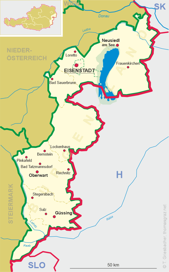
 Oberwart is situated at an elevation of 315 m on the river Pinka in southern Burgenland. The municipality has a population of about 7,000 (2009).
The settlement was established in the 11th century by the guards of the Hungarian frontier (őrök, singular: őr) together with Unterwart (Alsóőr) and Siget in der Wart (Őrisziget). It was first mentioned in historical documents in 1327 under the name Superior Eör. It was part of the old county of Vas (German: Eisenburg; capital Szombathely) until 1921. Old surnames and the special local dialect shows that the population was related to the Székelys of Transylvania (ie. the guards of the eastern border of Kingdom of Hungary). The community of the őrök received the privileges of the nobles by Károly Róbert I of Hungary (Charles Robert of Anjou) in the 14th century. The privileges were acknowledged by King Rudolf I (Holy Roman Emperor Rudolf II) in 1582. The village was partly destroyed by the Ottoman army in 1532. Reformation appeared in Felsőőr in the 16th century and it was backed by the mighty Counts of Battyhány. In the Age of Counter-Reformation most of the region had to return to Roman Catholic faith, but the free noble village of Felsőőr remained Calvinist. According to the laws of the Diet of 1681 Felsőőr became an "articular place" which means that it was the only legal place to practice Protestant religion for the whole region. The villagers participated in the Hungarian national uprisings of 1605 and 1705. In 1706 the Austrian army sacked Felsőőr. In 1841 the village received the right to held a market. After the Austro-Hungarian Compromise of 1867 the village began to develop rapidly and the population reached 3900 people in 1910. According to the Treaty of Paris (Trianon) in 1920, the predominantly German-speaking western parts of Hungary including Felsőőr were awarded to Austria, but the Hungarian population opposed the decision and organised a movement to establish the shortlived autonomous province of Lajtabánság. In November 1921 Oberwart finally became part of Burgenland as a new federal state of Austria. After the Anschluss with Germany in 1938 the Jewish inhabitants of the village (appr. 140 people) were deported, and the synagogue was transformed into a fire department depot. According to the Nazi policy of Germanisation, the old Hungarian school of the Reformed Church was secularized. In 1939 Oberwart was incorporated as a town. In April 1945 the Red Army occupied Oberwart after a week of fierce fighting and plundered the half-destroyed town. In the 1950s and 1960s Oberwart was rebuilt and thoroughly modernized.
 The
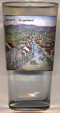
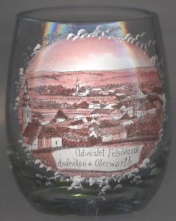
The  old parish church Mariä Himmelfahrt (Ascension of Our Lady) [left, no. 2693: far left, and right, no. 2584: background centre]
was enlarged and rebuilt in Gothic style in 1463. In the 16–17th centuries it was a Calvinist church. The tall tower was built during that time in 1656.
The church was rebuilt in Baroque style in 1728 and 1778. The restoration in 1975 revealed medieval architectural details and interesting murals in the apse from
the 14th century. The furniture is Baroque from the 18th century. The new parish church, dedicated to the Resurrection of the Lord, a modern concrete-and-glass church,
was built in 1967–1969 by the architects Günther Domenig and Eilfried Huth. Both churches are connected by a modern front building.
old parish church Mariä Himmelfahrt (Ascension of Our Lady) [left, no. 2693: far left, and right, no. 2584: background centre]
was enlarged and rebuilt in Gothic style in 1463. In the 16–17th centuries it was a Calvinist church. The tall tower was built during that time in 1656.
The church was rebuilt in Baroque style in 1728 and 1778. The restoration in 1975 revealed medieval architectural details and interesting murals in the apse from
the 14th century. The furniture is Baroque from the 18th century. The new parish church, dedicated to the Resurrection of the Lord, a modern concrete-and-glass church,
was built in 1967–1969 by the architects Günther Domenig and Eilfried Huth. Both churches are connected by a modern front building.
[Texts adapted from http://en.wikipedia.org/wiki/Oberwart]
![[scale]](lineal.jpg)