
|
|
| DEUTSCHLAND | GERMANY |
| Bundesland: Baden-Württemberg | |
| Regierungsbezirk: Karlsruhe | |
| Landkreis: Freudenstadt |
map →

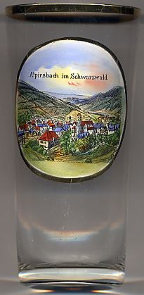 Alpirsbach is situated at an elevation of 563 m in the upper Kinzig valley in the district Freudenstadt in the
Swabian part of the Black Forest region of Baden-Württemberg. The municipality has a population of about 6,600 (2009) and also includes the formerly
independent communes of Ehlenbogen, Rötenbach, Reinerzau, Peterzell, Reutin and Römlinsdorf.
Alpirsbach is situated at an elevation of 563 m in the upper Kinzig valley in the district Freudenstadt in the
Swabian part of the Black Forest region of Baden-Württemberg. The municipality has a population of about 6,600 (2009) and also includes the formerly
independent communes of Ehlenbogen, Rötenbach, Reinerzau, Peterzell, Reutin and Römlinsdorf.
The monastery Alpirsbach was founded in 1095 by bishop Gebhard III of Konstanz from the Zähringer dynasty. The Benedictine monastery was dissolved when the Reformation was introduced in 1535 and the village became the seat of a district (Klosteramt) administration. Mining for gold, silver and cobalt began in the late 17th century and became important for the wealth of the community. In 1810 parts of the district Alpirsbach were incorporated into the district (Oberamt) Oberndorf. In 1806 Alpirsbach became part of the district (Oberamt) Freudenstadt which at that time was formed from the districts (Oberämter) Freudenstadt and Dornstetten including the districts (Klosterämter) Alpirsbach and Reichenbach. In 1869 Alpirsbach was chartered as a town. [https://de.wikipedia.org/wiki/Alpirsbach]
 Alpirsbach Abbey [right]
was founded in 1095 and was settled by Benedictine monks from Sankt Blasien.
The lord protectors were successively the counts of Zollern (1218 Hohenzollern),
the dukes of Teck and the counts of Württemberg.
The abbey was dissolved as a Catholic monastery in 1535 in the course of the Reformation by Duke Ulrich of Württemberg, but the buildings have continued in
Protestant use for various purposes until the present day.
[http://en.wikipedia.org/wiki/Alpirsbach_Abbey]
Alpirsbach Abbey [right]
was founded in 1095 and was settled by Benedictine monks from Sankt Blasien.
The lord protectors were successively the counts of Zollern (1218 Hohenzollern),
the dukes of Teck and the counts of Württemberg.
The abbey was dissolved as a Catholic monastery in 1535 in the course of the Reformation by Duke Ulrich of Württemberg, but the buildings have continued in
Protestant use for various purposes until the present day.
[http://en.wikipedia.org/wiki/Alpirsbach_Abbey]
![[scale]](lineal.jpg)