
|
|
| FRANCE | FRANCE |
| région: Grand Est | |
| département: 57, Moselle |
map →
 Thionville is situated at an elevation of 150 m at the river Moselle in the département Moselle of the
région Grand Est in northern France.
Thionville is the chef-lieu of the arrondissement Thionville and also of the canton of the same name.
The municipality of Thionville has a population of about 41,100 (2008).
Thionville is situated at an elevation of 150 m at the river Moselle in the département Moselle of the
région Grand Est in northern France.
Thionville is the chef-lieu of the arrondissement Thionville and also of the canton of the same name.
The municipality of Thionville has a population of about 41,100 (2008).
After the fall of the Western Roman Empire, the region was inhabited by the Germanic Alamanni and became part of the medieval Holy Roman Empire,
known as Diedenhofen in German. The Synod of Thionville was held here from 2 February 835. It reinstated Emperor Louis the Pious (Ludwig der Fromme) and reversed
his former conviction of crimes — none of which he actually committed — and deposed the Archbishop of Rheims, Ebbo.
On 28 February 835 in Mainz, Ebbo admitted that Louis had not committed the crimes of which he had been indicted and for which
he had been deposed as Holy Roman Emperor. Eskil, Archbishop of Lund, was imprisoned at Thionville (possibly at the instigation of the Archbishop of
Bremen) on his return from his 1153 pilgrimage to Rome. The Siege of Thionville in June 1639 occurred
as part of the Thirty Years' War (1618–1648). In 1659 Diedenhofen was annexed by France. The writer François-René de Chateaubriand was left for dead
during the military émigré expedition of prince Louis V de Bourbon (prince de Condé) against Thionville in 1792 (but was salvaged by friends and was taken to Jersey and exile in England). After the
Franco-Prussian War of 1870, the area of Alsace-Lorraine was annexed by the newly created German Empire in 1871 by the Treaty of Frankfurt
and became a 'Reichsland'; Thionville became Diedenhofen again. The German Army decided to build a fortress line from Mulhouse to Luxembourg to protect
their new Reichsland. The centerpiece of this line was the great 'Moselstellung', a fortress system protecting Metz and Thionville.
Following the armistice with Germany ending the First World War, the French army entered Thionville in November 1918 and the city was returned to France at
the Treaty of Versailles in 1919.
[Text adapted from http://en.wikipedia.org/wiki/Thionville]
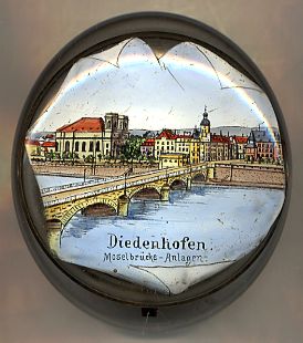
The  parish church of St. Maximin (Église de Saint-Maximin) [background left]
was built in 1755–1759. Since 1984 the church is listed as a historic monument. Thionville only consists of one parish,
named after St. Maximin, patron saint of the abbey St. Maximin in Trier, of which had been dependent since AD 930.
The oldest documented church had been erected in the 12th century at a different location but was moved to the current location in the 15th century.
During the siege of 1870 the church was severley damaged but was restored later.
parish church of St. Maximin (Église de Saint-Maximin) [background left]
was built in 1755–1759. Since 1984 the church is listed as a historic monument. Thionville only consists of one parish,
named after St. Maximin, patron saint of the abbey St. Maximin in Trier, of which had been dependent since AD 930.
The oldest documented church had been erected in the 12th century at a different location but was moved to the current location in the 15th century.
During the siege of 1870 the church was severley damaged but was restored later.
[http://fr.wikipedia.org/wiki/Thionville]
The Pont des Alliés [foreground]
with its 5 arches was built before 1914 to replace a previous structure of 1846.
The earliest documented ponton bridge at his place had been set up in 1606, the first firm bridge was constructed in 1673.
The bridge shown on the picture on glass no. 2652 was destroyed in 1944 and was replaced by a modern steel construction after the war.
[http://fr.wikipedia.org/wiki/Thionville]
![[scale]](lineal.jpg)