
|
|
| POLSKA | POLAND |
| województwo: Opolskie | voivodship: Opole |
| powiat: Głubczyce | county: Głubczyce |
map →
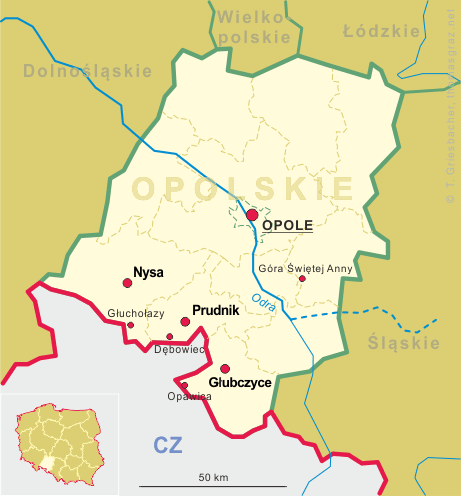
Głubczyce is situated at an elevation of 375 m in the Opole voivodship in southern Poland. The town is the seat of Głubczyce county. The municipality has a population of about 13,300 (2010). Gmina Głubczyce (urban-rural administrative district) covers an area of 294.3 km² with a total population of about 22,700 (2016) and consists of a total of 45 municipalities (former German names in parentheses): Bernacice (Wernersdorf), Bernacice Górne (Wernersdorf (Bahnhof)), Biernatów (Berndau) with Biernatówek (Klein Berndau), Bogdanowice (Badewitz, 1936–1945: Badenau) with Bogdanowice Kolonia (Badewitz Kolonie), Braciszów (Bratsch), Chomiąża (Komeise), Chróstno (Saliswalde), Ciermięcice (Türmitz), Debrzyca (Schönbrunn), Dobieszów (Dobersdorf), Gadzowice (Schmeisdorf), Głubczyce-Sady, Gołuszowice (Kreuzendorf), Grobniki (Gröbnig), Kietlice (Kittelwitz, 1936–1945: Kitteldorf), Klisino (Gläsen) with Klisinko (Klein Gläsen), Krasne Pole (Schönwiese), Królowe (Königsdorf), Krzyżowice (Kreisewitz), Kwiatoniów (Blümsdorf), Lenarcice (Geppersdorf) with Podlesie (Feldhof), Lisięcice (Leisnitz O.S.) with Nowosady (Neustift), Lwowiany (Schlegenberg) with Głubczyce-Las Marysieńka (Leobschütz-Stadtforst), Mokre (Mocker), Mokre–Kolonia (Bahnhof Mocker), Nowa Wieś Głubczycka (Neudorf), Nowe Gołuszowice (Neu Kreuzendorf), Nowe Sady (Kreuzwald), Nowy Rożnów (Neu Roznow), Opawica (Troplowitz), Pielgrzymów (Pilgersdorf), Pietrowice (Peterwitz, 1936–1945: Zietenbusch), Pomorzowice (Pommerswitz), Pomorzowiczki (Alt Wiendorf) with Stara Wieś (Neu Wiendorf), Radynia (Raden), Równe (Roben), Sławoszów (Amaliengrund) with Dobrogostów (Kolonie Karlsberg), Ściborzyce Małe (Steubendorf), Tarnkowa (Trenkau), Widok, Zawiszyce (Sabschütz) with Studzienica (Kaltenhausen), Zopowy (Soppau), Zopowy Osiedle (Soppau Siedlung), Zubrzyce and (Sauerwitz).
 The town was mentioned for the first time in 1107. At the time, it was a small Moravian village, named Glubcici, and
was dominated by a large wooden castle. The town stood on the right bank of the Psina River, which from 1137 on formed the
border between Moravia and Silesia. The exact date of the city's founding is unknown, but it is traceable, back to 1224,
that the city is also Lubschicz, a settlement founded by Ottokar I of Bohemia. In 1270, city rights were granted
to the town by Ottokar II. In 1298, the town received expanded rights from Venceslaus II. In 1365, the town became
the seat of a principality, and in 1482, the town was the seat of the Přemyslids. The city lost its status as a
principality seat in 1503, and the principality ceased to exist. The city was transferred to the control of the principality
of Jägerndorf (now Krnov). The city came under the rule of Prussia in 1743 and was made the
capital city of its Landkreis, or district. After World War I and the creation of the Republic of Poland, the Silesian
plebiscite was held in Upper Silesia. The percentage of 99.5% of Leobschütz citizens voted for Germany. The Silesian
Uprisings did not directly affect the city, which had almost exclusively German-speaking inhabitants. After the Nazis came
to power in Germany in 1933, the town hosted schools and training grounds for both the SS and the SA. In 1945, the Red Army
occupied the town. After the Soviet occupation, the name of the town was changed to Głubczyce, its current
name. The city was transferred, like most of Silesia, to the People's Republic of Poland. The remaining German population
was replaced by Polish colonists and refugees transferred from the Kresy in the former Polish east. The city became seat of
a county, or Powiat. Głubczyce lost that distinction in 1975, but regained it in 1999.
The town was mentioned for the first time in 1107. At the time, it was a small Moravian village, named Glubcici, and
was dominated by a large wooden castle. The town stood on the right bank of the Psina River, which from 1137 on formed the
border between Moravia and Silesia. The exact date of the city's founding is unknown, but it is traceable, back to 1224,
that the city is also Lubschicz, a settlement founded by Ottokar I of Bohemia. In 1270, city rights were granted
to the town by Ottokar II. In 1298, the town received expanded rights from Venceslaus II. In 1365, the town became
the seat of a principality, and in 1482, the town was the seat of the Přemyslids. The city lost its status as a
principality seat in 1503, and the principality ceased to exist. The city was transferred to the control of the principality
of Jägerndorf (now Krnov). The city came under the rule of Prussia in 1743 and was made the
capital city of its Landkreis, or district. After World War I and the creation of the Republic of Poland, the Silesian
plebiscite was held in Upper Silesia. The percentage of 99.5% of Leobschütz citizens voted for Germany. The Silesian
Uprisings did not directly affect the city, which had almost exclusively German-speaking inhabitants. After the Nazis came
to power in Germany in 1933, the town hosted schools and training grounds for both the SS and the SA. In 1945, the Red Army
occupied the town. After the Soviet occupation, the name of the town was changed to Głubczyce, its current
name. The city was transferred, like most of Silesia, to the People's Republic of Poland. The remaining German population
was replaced by Polish colonists and refugees transferred from the Kresy in the former Polish east. The city became seat of
a county, or Powiat. Głubczyce lost that distinction in 1975, but regained it in 1999.
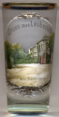
The picture on glass no. 2718 [left] is labeled  Am Doctorgang Landratsamt (Starostwo) (district office), today Urząd Miasta i Gminy (town hall and municipal office).
[http://en.wikipedia.org/wiki/Głubczyce, http://www.leobschuetz-oberschlesien2.de/40208.html]
![[scale]](lineal.jpg) contact: webmaster
contact: webmaster