
|
|
| DEUTSCHLAND | GERMANY |
| Bundesland: Niedersachsen | Lower Saxony |
| Landkreis: Wesermarsch |
map →
 Nordenham is situated at an elevation of 3 m in the Wesermarsch district of Lower Saxon, on the left, west, bank of the river Weser, opposite of
Bremerhaven. The city of Nordenham consists of the localities Abbehausen, Abbehauser Groden, Abbehauser Hörne, Abbehauserwisch, Atens, Atenserfeld,
Blexen, Blexersande, Blexerwurp, Bulterweg, Butterburg, Einswarden, Ellwürden, Enjebuhr, Esenshamm, Esenshammer Altendeich, Esenshammer Oberdeich, Esenshammergroden,
Friedrich-August-Hütte, Grebswarden, Großensiel, Havendorf, Heering, Hoffe, Kloster, Moorseersand, Oberdeich, Phiesewarden, Rahden, Sarve, Schockumerdeich, Schweewarden,
Schütting, Tettens, Treuenfeld, and Volkers. Also part of Nordenham are the islands Langlütjen I and Landlütjen II, which in the 19th century were created artificially
in the Weser estuary. The municipality of Nordenham has a population of 26,700 (2011).
Nordenham is situated at an elevation of 3 m in the Wesermarsch district of Lower Saxon, on the left, west, bank of the river Weser, opposite of
Bremerhaven. The city of Nordenham consists of the localities Abbehausen, Abbehauser Groden, Abbehauser Hörne, Abbehauserwisch, Atens, Atenserfeld,
Blexen, Blexersande, Blexerwurp, Bulterweg, Butterburg, Einswarden, Ellwürden, Enjebuhr, Esenshamm, Esenshammer Altendeich, Esenshammer Oberdeich, Esenshammergroden,
Friedrich-August-Hütte, Grebswarden, Großensiel, Havendorf, Heering, Hoffe, Kloster, Moorseersand, Oberdeich, Phiesewarden, Rahden, Sarve, Schockumerdeich, Schweewarden,
Schütting, Tettens, Treuenfeld, and Volkers. Also part of Nordenham are the islands Langlütjen I and Landlütjen II, which in the 19th century were created artificially
in the Weser estuary. The municipality of Nordenham has a population of 26,700 (2011).
 Some of the oldest parts of the modern town area are the old villages or 'Wurtendörfer' (roughly translated as 'terp villages') Blexen, Einswarden and Atens. Bishop Willehad,
the Northumbrian-born missionary of the Frisians, died in Blexen in the year 789, which is also commonly accepted to be the villages year of foundation. In 1407, the Vredeborch
or Friedeburg (to be translated as "peace castle") was erected by the Hanseatic city of Bremen, a castle (although it was probably more a kind of large
fortified house) to protect interests against the rebellious inhabitants, the Rüstringer Frisians. The stronghold was destroyed in 1425 and it is possible that the site was later
used by a monastery. Between 1499 and 1514 the area was conquered by the County of Oldenburg and in 1813 by the French emperor Napoleon, whose army shot
ten local inhabitants at the church in Blexen. Nordenham began to develop from the community of Atens in the late 19th century after the efforts by a merchant called Wilhelm Müller
who traded cattle and sheep to England. Originally, the town's name was spelled Nordenhamm, with a double 'm', but the spelling with a single 'm' also was used frequently.
In order to avoid confusion, the government of the Grand Duchy of Oldenburg decided in 1887 that the official spelling should be Nordenham. In 1875 the railway line
from Hude (about hafway between Oldenburg and Bremen) and Nordenham opened.
On 1 May 1908 Nordenham was granted 2nd class town rights and since 1955 Nordenham is an independent town in the Wesermarsch district.
Some of the oldest parts of the modern town area are the old villages or 'Wurtendörfer' (roughly translated as 'terp villages') Blexen, Einswarden and Atens. Bishop Willehad,
the Northumbrian-born missionary of the Frisians, died in Blexen in the year 789, which is also commonly accepted to be the villages year of foundation. In 1407, the Vredeborch
or Friedeburg (to be translated as "peace castle") was erected by the Hanseatic city of Bremen, a castle (although it was probably more a kind of large
fortified house) to protect interests against the rebellious inhabitants, the Rüstringer Frisians. The stronghold was destroyed in 1425 and it is possible that the site was later
used by a monastery. Between 1499 and 1514 the area was conquered by the County of Oldenburg and in 1813 by the French emperor Napoleon, whose army shot
ten local inhabitants at the church in Blexen. Nordenham began to develop from the community of Atens in the late 19th century after the efforts by a merchant called Wilhelm Müller
who traded cattle and sheep to England. Originally, the town's name was spelled Nordenhamm, with a double 'm', but the spelling with a single 'm' also was used frequently.
In order to avoid confusion, the government of the Grand Duchy of Oldenburg decided in 1887 that the official spelling should be Nordenham. In 1875 the railway line
from Hude (about hafway between Oldenburg and Bremen) and Nordenham opened.
On 1 May 1908 Nordenham was granted 2nd class town rights and since 1955 Nordenham is an independent town in the Wesermarsch district.
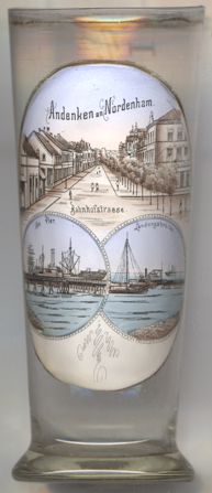
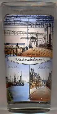
The pictures on glass no. 2789 [near left] are labeled
 Auf dem Fischerei-Hafen Bahnhof-Straße
[https://de.wikipedia.org/wiki/Nordenham, http://en.wikipedia.org/wiki/Nordenham]
![[scale]](lineal.jpg)