
|
|
| ÖSTERREICH | AUSTRIA |
| Bundesland: Niederösterreich | Lower Austria |
| Bezirk: Horn |
map →

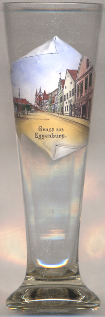 Eggenburg is situated at an elevation of 329 m on the river Schmida
on the northeastern edge of the hill Mannhartsberg at the border between the regions
Waldviertel and Weinviertel. It was first mentioned in a document in 1125.
Eggenburg is situated at an elevation of 329 m on the river Schmida
on the northeastern edge of the hill Mannhartsberg at the border between the regions
Waldviertel and Weinviertel. It was first mentioned in a document in 1125.
 The
The  parish church Sankt Stephan [background centre]
was first mentioned in 1260. The two east towers date from the 12th century and
already were part of the previous, romanesque church. The present gothic church was commenced
1482–1485, but building work had to be stopped after the completion of the walls
of the nave and chancel when King Matthias Corvinus of Hungary conquered the town.
After the end of the Hungarian occupation 1491 the vaulting of the nave and the chancel
was completed prior to 1515 and the church was consecrated in 1537.
parish church Sankt Stephan [background centre]
was first mentioned in 1260. The two east towers date from the 12th century and
already were part of the previous, romanesque church. The present gothic church was commenced
1482–1485, but building work had to be stopped after the completion of the walls
of the nave and chancel when King Matthias Corvinus of Hungary conquered the town.
After the end of the Hungarian occupation 1491 the vaulting of the nave and the chancel
was completed prior to 1515 and the church was consecrated in 1537.
The Dreifaltigkeitssäule (Trinity Column) [centre]
on the main square (Hauptplatz) was erected 1713–1715.

![[scale]](lineal.jpg)