
|
|
| DEUTSCHLAND | GERMANY |
| Bundesland: Freistaat Sachsen | Saxony |
| Landkreis: Sächsische Schweiz-Osterzgebirge |
map →

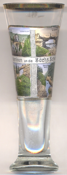
 The Kuhstall ('Cowshed') [top right picture]
is the second largest natural arch in the Elbe Sandstone Mountains after the Prebischtor (Pravčická brána, CZ).
It is located on the Neuer Wildenstein, a 337 m high rock outcrop in the hinterland of Saxon Switzerland, south of the Lichtenhain Waterfall and above the Kirnitzsch valley.
It is crowned by the 15th-century castle of Wildenstein. The arch is 11 m high, 17 m wide and 24 m deep.
The name Kuhstall has two possible origins. The first posit is that the local population hid their cattle in the very wide natural archway from marauding Swedish soldiers during
the Thirty Years' War (1618–1648). The second is that the occupants of the medieval castle, that towards the end became a haven for robber knights, kept the cattle here that
they had stolen during their raids. The first developer of Saxon Switzerland, Wilhelm Lebrecht Götzinger, suggested that the natural arch should be called the Wildenstein Rock Hall
('Wildensteiner Felsenhalle') instead of the traditional and folksy Kuhstall, but was not able to prevail. From the time when the area was first developed for tourism, there are
many old inscriptions, that that been written on the walls and roof of the Kuhstall with soot and paint or scratched into the rock.
In the early 19th century the Kuhstall developed into one of the main attractions of Saxon Switzerland. It was an important station along the Artists' Way (Malerweg).
The Kuhstall ('Cowshed') [top right picture]
is the second largest natural arch in the Elbe Sandstone Mountains after the Prebischtor (Pravčická brána, CZ).
It is located on the Neuer Wildenstein, a 337 m high rock outcrop in the hinterland of Saxon Switzerland, south of the Lichtenhain Waterfall and above the Kirnitzsch valley.
It is crowned by the 15th-century castle of Wildenstein. The arch is 11 m high, 17 m wide and 24 m deep.
The name Kuhstall has two possible origins. The first posit is that the local population hid their cattle in the very wide natural archway from marauding Swedish soldiers during
the Thirty Years' War (1618–1648). The second is that the occupants of the medieval castle, that towards the end became a haven for robber knights, kept the cattle here that
they had stolen during their raids. The first developer of Saxon Switzerland, Wilhelm Lebrecht Götzinger, suggested that the natural arch should be called the Wildenstein Rock Hall
('Wildensteiner Felsenhalle') instead of the traditional and folksy Kuhstall, but was not able to prevail. From the time when the area was first developed for tourism, there are
many old inscriptions, that that been written on the walls and roof of the Kuhstall with soot and paint or scratched into the rock.
In the early 19th century the Kuhstall developed into one of the main attractions of Saxon Switzerland. It was an important station along the Artists' Way (Malerweg).
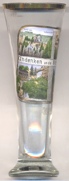
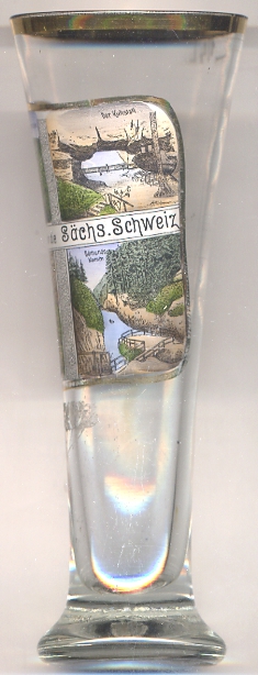
Glass no. 2973, labeled as a souvenir from the Sächsische Schweiz ('Saxon Switzerland'), also shows view of the Bastei-Brücke,
Prebischtor (Pravčická brána, CZ) and Edmundsklamm (Edmundova soutěska, CZ).
[https://en.wikipedia.org/wiki/Kuhstall_(Saxon_Switzerland)]
![[scale]](lineal.jpg)