
|
|
| DEUTSCHLAND | GERMANY |
| Bundesland: Freistaat Sachsen | Saxony |
| Landkreis: Mittelsachsen |
map →

 Roßwein is situated at an elevation of 204 m on the river Freiberger Mulde in Saxony's district Mittelsachsen, about 10 km southeast od
Döbeln and 25 km northwest of the district's capital, Freiberg.
The municipalit of Roßwein has a population of about 6,600 (2012).
Roßwein is situated at an elevation of 204 m on the river Freiberger Mulde in Saxony's district Mittelsachsen, about 10 km southeast od
Döbeln and 25 km northwest of the district's capital, Freiberg.
The municipalit of Roßwein has a population of about 6,600 (2012).
Rosewin was first mentioned in awritten document in 1220. The name is of Sorbic origin and has its roots in the name Rusava, which itself goes back to 'rusy' (reddish, blond, brown). In 1286 the town was first medntioned as 'civitas seu oppidum', a town. In 1293 it came in possession of the Cistercian monastery Altzella near Nossen. The railway to Leipzig and Dresden opened in 1868, the railway to Chemnitz in 1874.
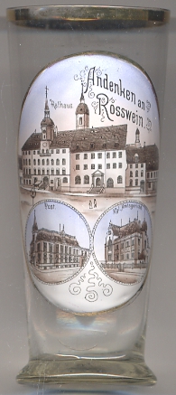
The  town hall [top picture]
was rebuilt in 1862. A portal from an earlier building, dating from 1529, has been preserved.
town hall [top picture]
was rebuilt in 1862. A portal from an earlier building, dating from 1529, has been preserved.
The old post office building [bottom left picture]
was built in 1891.
The former district court (Amtsgericht) [bottom left picture]
superseded the former 'court office' (Gerichtsamt) in 1879. Its judicial area included the town of Roßwein as well as 26 rural communities.
In 1945 the ditrict court became a branch court of the district court at Döbeln. The court at Roßwein was dissolved in 1952.
[https://de.wikipedia.org/wiki/Roßwein;
https://de.wikipedia.org/wiki/Roßwein;
http://www.archiv.sachsen.de/archive/leipzig/4198_3230313333.htm]
![[scale]](lineal.jpg)