
|
|
| DEUTSCHLAND | GERMANY |
| Bundesland: Baden-Württemberg | |
| Regierungsbezirk: Freiburg | |
| Landkreis: Waldshut |
map →

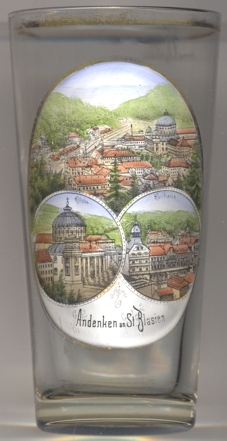 Sankt Blasien is situated at an elevation of 770 m in the Alb valley of the southern Black Forest region, in the
district Waldshut. The municipality of Sankt Blasien has a population of about 3,800 (2014).
Sankt Blasien is situated at an elevation of 770 m in the Alb valley of the southern Black Forest region, in the
district Waldshut. The municipality of Sankt Blasien has a population of about 3,800 (2014).
The former  Benedictine Abbey was first mentioned in a document dating from AD 858.
From the lete Middle Ages onwards, the monastery was one of the most important monastic centres in the south German region.
The impressive monastery church [bottom left]
with its characteristic large dome was built in 1771–1781, after a large fire had
destroyed the older church. The new church was built according to a neo-classical design by the architects
Pierre Michel d'Ixnard and Nicolas de Pigage. However, already in 1806 the monastery was secularised.
the secular domains of the monastery were transfered to the Grand Duchy of Baden, while
the monks in 1809 relocated to the monastery of Sankt Paul im Lavanttal, which itself had been secularised in 1782/85.
At first, there were plans to tear down the monastery as it seemed too expensive to keep it up without having any
specific use for the duke. However, the complex was finally sold and became home of one of the earliest mechanised
factories in Germany. From 1934, the remaining buildings have been occupied by the well-known Jesuit college,
the Kolleg St. Blasien. The former monastery church remained in use as a church and solely because of its
size is popularly refered to as Dom ('cathedral'). The effects of another catastrophic fire in 1874 were
only finally remedied in the 1980s.
Benedictine Abbey was first mentioned in a document dating from AD 858.
From the lete Middle Ages onwards, the monastery was one of the most important monastic centres in the south German region.
The impressive monastery church [bottom left]
with its characteristic large dome was built in 1771–1781, after a large fire had
destroyed the older church. The new church was built according to a neo-classical design by the architects
Pierre Michel d'Ixnard and Nicolas de Pigage. However, already in 1806 the monastery was secularised.
the secular domains of the monastery were transfered to the Grand Duchy of Baden, while
the monks in 1809 relocated to the monastery of Sankt Paul im Lavanttal, which itself had been secularised in 1782/85.
At first, there were plans to tear down the monastery as it seemed too expensive to keep it up without having any
specific use for the duke. However, the complex was finally sold and became home of one of the earliest mechanised
factories in Germany. From 1934, the remaining buildings have been occupied by the well-known Jesuit college,
the Kolleg St. Blasien. The former monastery church remained in use as a church and solely because of its
size is popularly refered to as Dom ('cathedral'). The effects of another catastrophic fire in 1874 were
only finally remedied in the 1980s.
The bottom right picture on glass no. 3059 shows a view of the
Kurhaus
[https://de.wikipedia.org/wiki/St._Blasien, https://en.wikipedia.org/wiki/St._Blaise_Abbey,_Black_Forest]
![[scale]](lineal.jpg)